|
Hidden East Anglia: |
The Puddingstone Track: Deconstructed |
|
|
Puddingstone Track Deconstructed: |
Along the Track: BUCKINGHAMSHIRE
Part 3: Puddingstones in Chesham
Down the hill from the village of Botley, the Track is supposed to enter Chesham from the east, cross the market place to the church, turn south to the former ford over the river Chess, then head west towards Great Missenden. In 'The Lost Trackway' Dr. Rudge mentions only three markers on his Track in the town of Chesham: the 'Market Stone', the alleged 'stone circle' beneath St. Mary's church, and the 'ford stone' at the junction of Pednormead End and Church Street.
His 1952 article however notes other stones, that were never mentioned again: "A remarkable number of the old trackstones still stand in Church Road [sic], Chequers Yard, and Lewin's Yard, and we have collected detailed records of others. All lie on the east-to-west line, and few puddingstones are found at other points of the compass".1
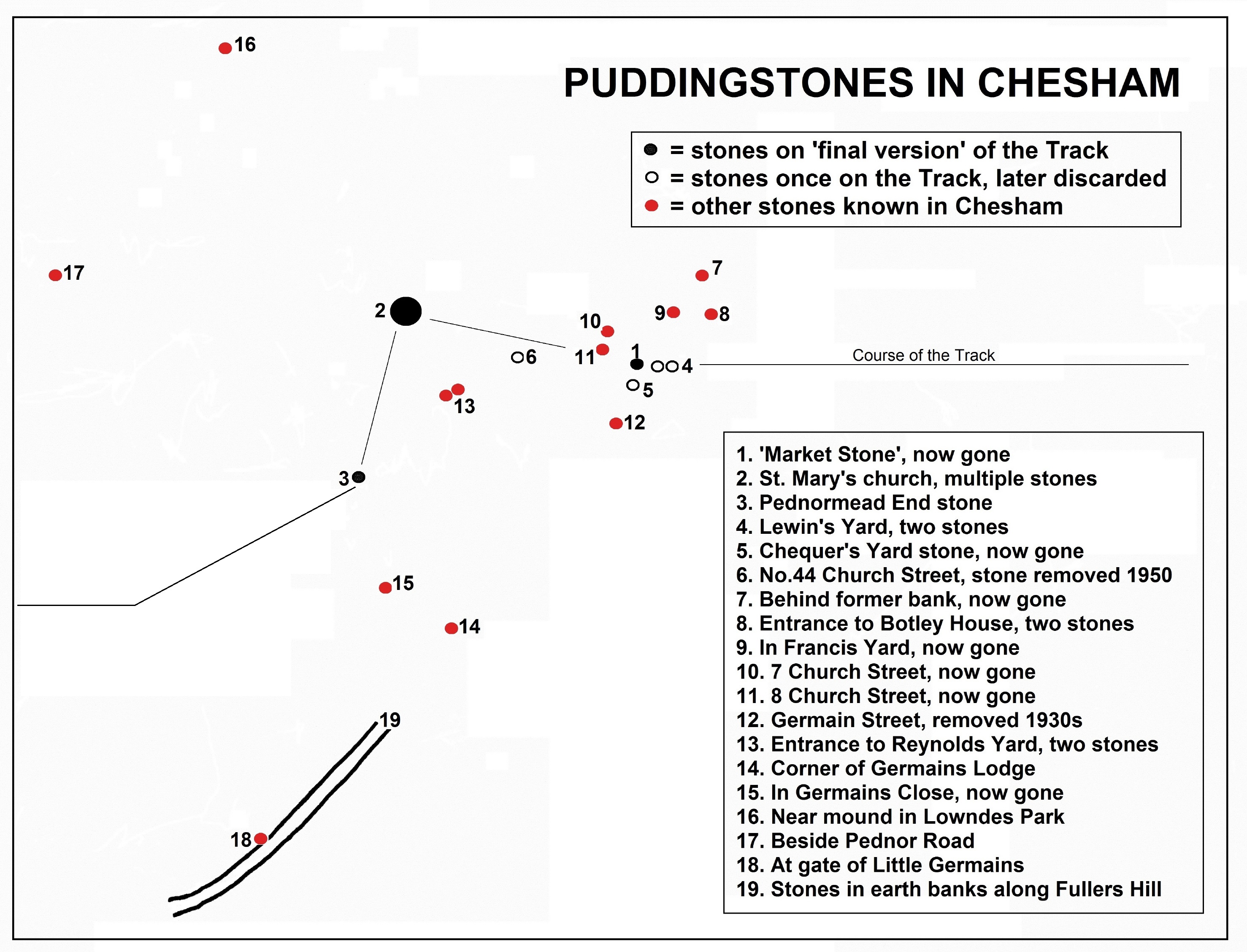
The map below - which I've put together from multiple sources as well as personal observation - tells a different story.
Exactly why he discarded three of the stones (Nos.4, 5 and 6) is unclear, since Rudge could still have made them fit the line of the Track (which isn't really east-to-west at all.) But he blatantly ignored many others that didn't conform to his theory. Some are (or were) fairly small, or loose on the surface, or had clearly come from elsewhere - in other words, just the same as some that Rudge accepted onto his Track. Others were more substantial, like the block over 2m long once behind the NatWest bank, and the similar-sized one moved to Middlesex in about 1936.2 There is another large block of puddingstone in Lowndes Park, close to the mound (of uncertain date) known as the Rolling Pin. The rector of the church told me of a second such boulder in the park, but I was unable to locate it.
Heading south-westerly out of the town, and rising as it goes, is the road called Fuller's Hill. As the Chesham Heritage Trail leaflet says, this is "an ancient road with large puddingstones sunk deeply into its banks".3 Nowadays the banks only begin after about 300m, and the only visible puddingstones are on the west side, smallish rocks embedded by a gateway and the corner of a house, along with a few loose blocks.
The spread of puddingstone around the town - and we only know about those that have survived or been recorded - shows that, as usual, Dr. Rudge simply picked and chose which ones were useful to his theory of the Track. As at St. Albans and other places along the route, Chesham lies in an area well-known for puddingstone. Apart from those in the immediate vicinity of the town, about 1¼ miles north of the market place is Vale Farm, which holds a fine collection of boulders gathered from the surrounding countryside. About the same distance away but to the north-east is Lye Green, where some puddingstone blocks were recorded in the 1950s by Davies and Baines, and two still survive on the verges of Lycrome Road. Three-quarters of a mile south-east of the market place, a large boulder is embedded by a footpath near Hill Farm. Here begins the old track called Green Lane, where the Town Guide of 1970 said to "look out for puddingstones." It leads over the parish boundary to White End Park Farm, where sits a large heap of conglomerates unearthed less than a mile away. Just to the north, between the farm and Botley, is a substantial puddingstone at Cowcroft Farm, with others occasionally uncovered at the nearby brickworks quarry. Cowcroft sits on Tyler's Hill, which plateaus to the west then slopes down into Chesham itself, roughly along the line of Rudge's Track.
With other boulders surviving or recorded at Amersham, Chesham Bois, Chartridge, Hawridge and Ashley Green, Chesham actually sits at the heart of 'puddingstone country' in the Chilterns. Out of all those in the town Rudge selected two, plus a church with puddingstones in its fabric, as evidence of his theory. How many more might have existed in the past is unknown, which makes his selection utterly disingenuous.
References: 1. E.A. & E.L. Rudge: 'The Conglomerate Track' in 'Essex Naturalist' Vol.29, part 1 (March 1952), p.30. 2. A. Morley Davies & Arnold H. Baines: 'A Preliminary Survey of the Sarsen & Puddingstone Blocks of the Chilterns' in 'Proceedings of the Geologists' Association', Vol.64, Pt1 (1953),pp.2, 6. 3. 'Chesham Heritage Trail: Chesham Walks 1' (The Chesham Society 1980, revised 2013.)
|
|
