|
Hidden East Anglia: |
The Puddingstone Track: Deconstructed |
|
|
Puddingstone Track Deconstructed: |
Issues of Geology and Topography
1. Random distribution:
In 1954, the third of Rudge's articles about his Track appeared in the 'Essex Naturalist'.1 As stated in the previous section, 'Unconvincing Evidence', this one was in defence of his theory as applied solely to Essex, and an apparent - though indirect - response to criticism by S. Hazzledine Warren.2
Rudge stated that "It occurred to us, very early in this work, that the chief objection to our claim that these stones formed an alignment would rest upon the random distribution of these stones throughout the district. In other words, our critics would suggest that we had merely drawn a continuous line arbitrarily through the sites of such boulders as most conveniently served our purpose. At all times, therefore, we have conducted a painstaking search for puddingstone boulders far beyond the region crossed by our line." (The nature of that search, and its inherent flaws, will be examined in the next section of this study.) This also seems to have been a rejoinder to the geologist Dr. A Morley Davies, who had earlier objected that "To prove his [Rudge's] case it is not enough to find a series of conglomerate blocks along a chosen line; he must also prove their absence or comparative rarity in the area on both sides of this line".3
Of course, the distribution of puddingstone boulders across the landscape today (and in Rudge's time) is only random in the sense that no single controlling entity or force placed them there. But many surviving blocks were set in their current locations by humans, who had all sorts of random and non-random reasons for doing so. Rudge, naturally, believed that those on his Track were placed there more than 5000 years ago for a singular purpose.
When beginning his quest for puddingstone in his home county, Rudge leaned heavily on the only available published information, A.E. Salter's 1914 list of Essex boulders. 4 Warren commented that, "in spite of the inadequacy of Salter's list, I think it does suggest that the course [of the Track] passes through the greatest occurrence of puddingstones in Essex. As these are not only found on the surface, but also buried in the glacial drifts, this occurrence, on the whole, is natural, and not within the scope of archaeology."
Rudge also thought Salter's list to be inadequate, claiming that "the 20 puddingstone boulders he mentions represent less than one-sixth of the total we have since discovered." But he was keen to point out that "of Salter's 20 stones, no less than five are members of our series." (Unaccountably, in 'Lost Trackway' he states that only the Holyfield stone is common to both Salter and the Track.) One of those five, at Fordham, was actually a sarsen although Rudge claimed otherwise - despite the fact that he had never seen it.
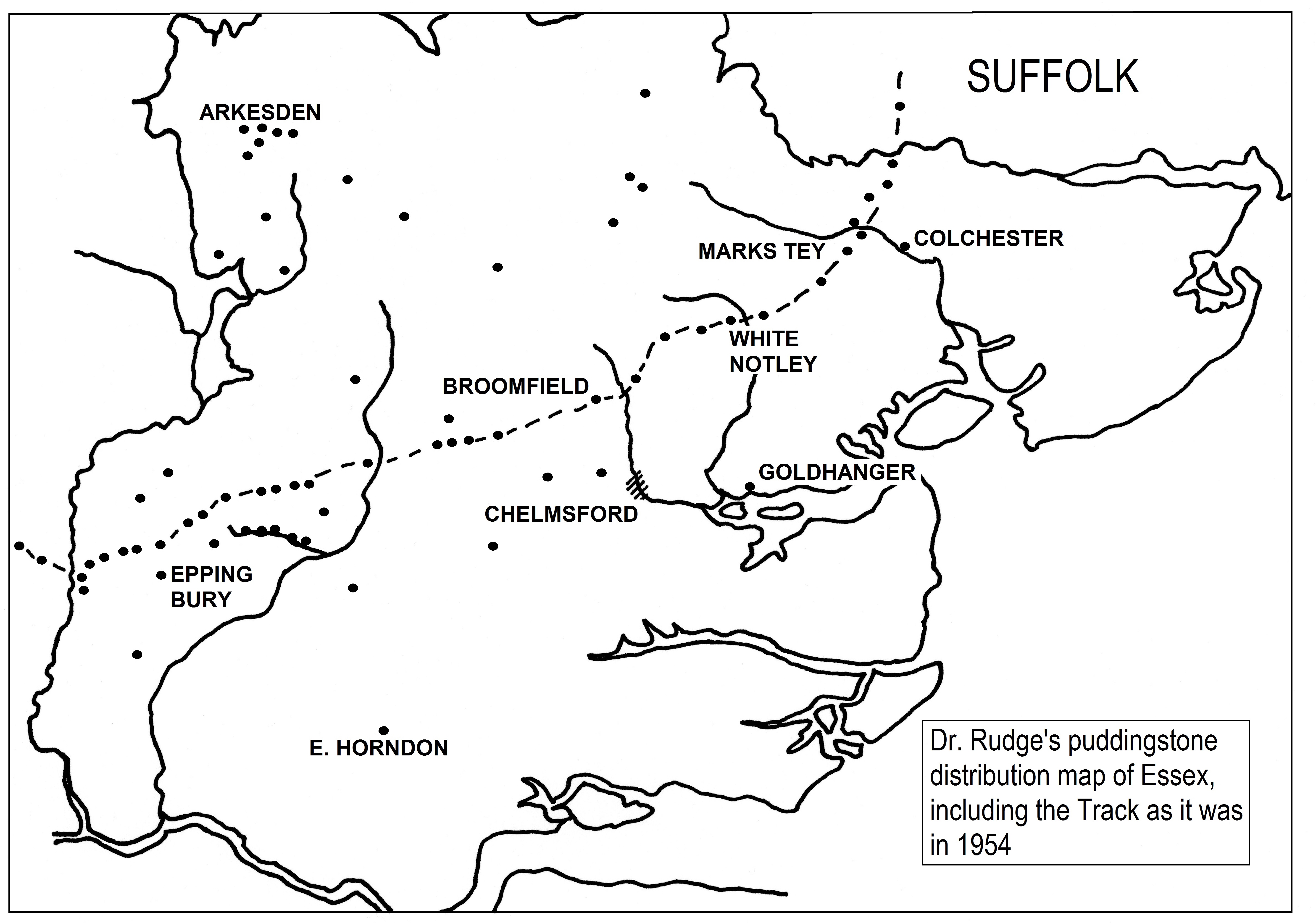
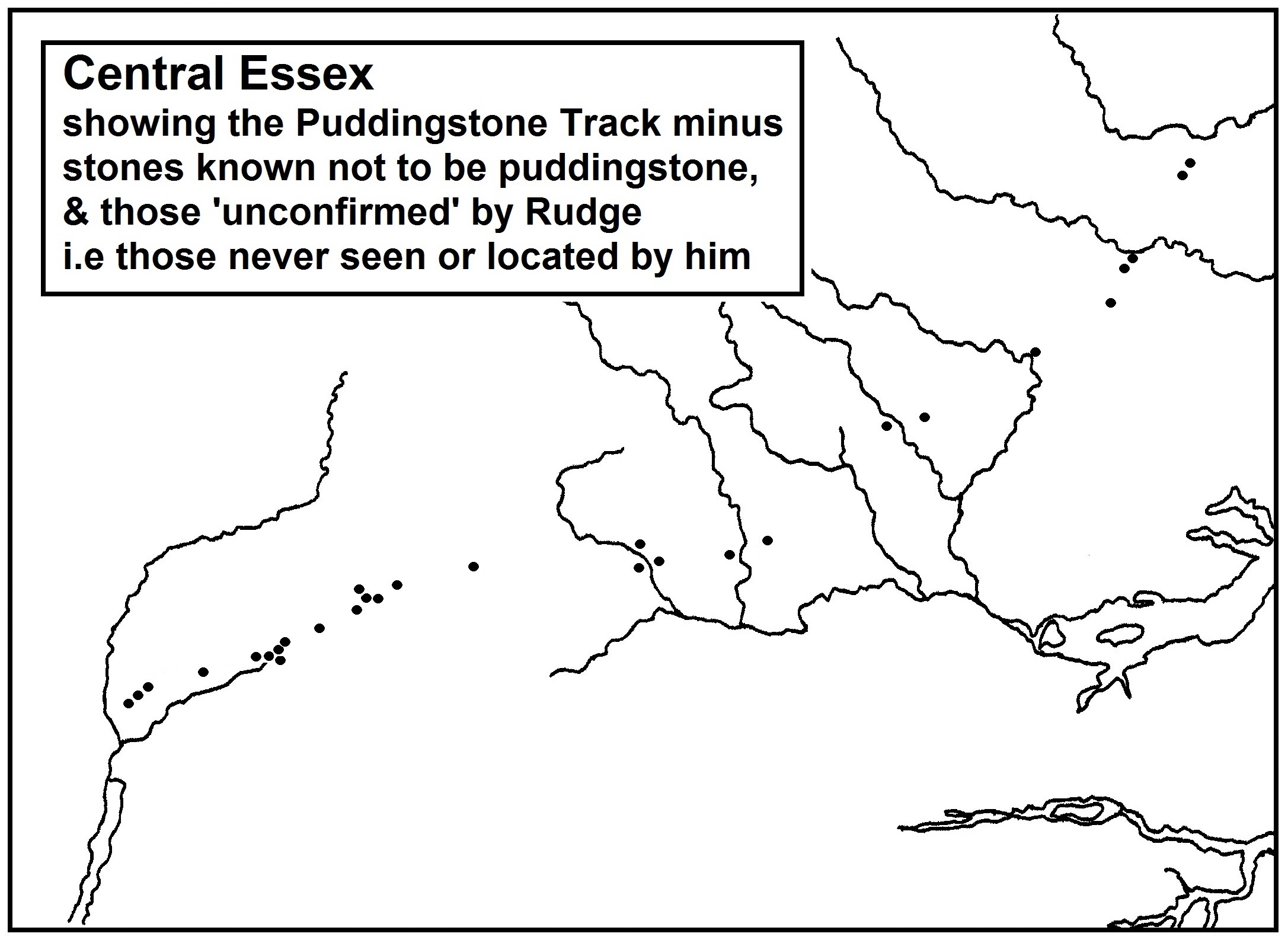
To accompany his 1954 article, he produced a map of puddingstone distribution within Essex, drawn from both Salter and his own fieldwork. It included the stones and course of his Track as they stood at that time. I've reproduced that map above, redrawn for clarity by removing some unnecessary place-names. Even though the map is small scale, Rudge omitted many stones that could have been marked, including most of Salter's. He even omitted three that had previously featured on his Track then were later discarded, as well as adding in three others that never appeared on any version of his route. He marked one puddingstone at Goldhanger, which he said was at the crossroads near the church. Unfortunately, this is actually made of granite, and is one semi-circular half of the press from a cider mill - a fact that had been known since 1911. And as a final error of fact - Salter actually listed more than 30 conglomerates, not the 20 claimed by Rudge. Nevertheless, he asserted that, apart from two clusters (one along the Cripsey Brook, and one around Arkesden far from the Track), "elsewhere in the county, puddingstone boulders occur in isolated and widely-scattered areas, in strong contrast with the closely-packed series of our trail." We need to look at that alleged "closely-packed series." Following from stone to stone, between Little Horkesley and Holyfield the Track traverses about 43 miles of the Essex landscape. Along that 43 miles, the final version of the Track details 40 puddingstones - less than one a mile. The ratio naturally worsens when we remove the five Track-stones that are not actually puddingstone at all (i.e. at Rams Farm and by the church at Fordham, by the former shop at Fordstreet, in Beauchamp Roding churchyard, and at Chambers Manor in Epping Upland.) Then there are those that even Rudge classed as 'unconfirmed' as he never saw them, and often couldn't pin down a location. These would include a boulder reported somewhere near Felix Hall in Kelvedon, the 'block of concrete' that was never found in Ivy Wood at Terling, a destroyed stone near Broomfield, a long-buried stone at Orange Hill, Epping Upland, and the alleged boulders somewhere on Galley Hill and in Deerpark Wood near Holyfield. Not only couldn't Rudge be sure that any of these were conglomerates, with some the lack of a precise location meant that he shouldn't even have included them as part of his Track. The map below shows how the Track would look without those stones known not to be puddingstone, and without those that are 'unconfirmed' due to never being seen or located by Rudge.
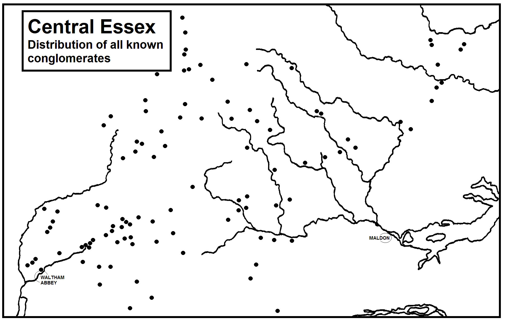
Using Salter, Rudge and dozens of other sources, I've compiled my own database of known conglomerates (HPS, ferricrete and other types), which includes many discovered since Rudge's time, as well as some already known but unrecorded by him. The map below, which is as accurate as I can make it, shows the distribution in central Essex only, including the 'reduced' (i.e. more factual) Track from the second map.
It's tempting also to rule out the stone at Marks Tey church - which is just one of a multitude of conglomerates in the building's fabric and contradicts Rudge's own criteria - as well as the 'fragments' in the Pinchtimber Farm pond which could have come from anywhere in the surrounding fields. But for the moment I have left them in. With the removal of the non-genuine and specious stones, it can be seen that the Track is less of a 'series' and more of a few small unconnected clusters along with isolated specimens. As Rudge and his wife are the only people known to have ever specifically searched for puddingstone in Essex, their discovery of these clusters is hardly surprising. More importantly, they found them along a roughly south-west to north-east axis because that was the course they had already projected in the first summer of their search - one which needed to lead to their hypothesised goal of Grime's Graves. As is usual, it was a case of 'find the most where you look the hardest'. Even with a generous reading of the evidence, the notion that it is 'closely-packed' also falls apart under scrutiny. At Magdalen Laver there are four conglomerates within about ¾ of a mile - although one of them would take the traveller in a different direction. At Epping Upland six stones line the same road in a distance of just over two miles - although one is not a puddingstone, one was never seen by Rudge, and one is the Pinchtimber fragments. But elsewhere along the Track in Essex there are seven gaps ranging from 1½ to 5 miles in length where no stone was ever found. One of the small concentrations of conglomerate boulders that Rudge highlights on his map - not on the Track, but close to it - is along the valley of Cripsey Brook between Moreton and Epping Upland. Here, as was noted in 1893, the Brook has "cut through the Boulder-Clay and exposed the underlying Glacial Gravel".5 He rejected from his Track any stones found in this area because, as he stated in 1954, "Many of these boulders have been retrieved from the stream-bed in recent times, and, indeed, are still extensively used as a rockery material." Yet six of the stones accepted onto his Track are within one mile of the Brook, and another four just a little further away. By his own logic, any of them could have been taken from the stream at any time in the last few hundred years, including the cluster of four at Magdalen Laver. There are at least another six boulders that I know of within the same radius that he seemingly ignored. The apparent cluster of Track-stones and other conglomerates between Harlow and Waltham Abbey, where the Track runs down to the river Lea near Holyfield, is also explicable in geological terms. The whole area is virtually bounded on three sides by depositions of the Reading Beds (Lambeth Group) where Herts Puddingstone originated, namely beneath Old Harlow, the valley of the Lea just north of Holyfield, and much of Epping Forest. This may have been unknown to Rudge, who said wrongly in 1952 that "the natural rock does not occur within a distance of five miles of the district".6
"Drawing a line from one stone to another looks attractive," said Warren, "but it is difficult to be sure that one is not putting one's own ideas into them." Given the greater density of conglomerates in central Essex than Rudge had mapped, it's not impossible to 'connect the dots' and discern several apparent lines across the county, but they're all illusory, as will become evident below.
References: 1. E.A. Rudge: 'Statistical Evidence for a Conglomerate Alignment in Essex' in Essex Naturalist' Vol.29, part 3 (1954), p.178-186. 2. S. Hazzledine Warren: 'The Conglomerate Track' in 'Essex Naturalist' Vol.29, part 3 (1954), p.176-7. 3. A. Morley Davies: 'Neolithic Stones' in the 'Bucks Examiner' September 8th 1950. 4. A.E. Salter: 'Sarsen, Basalt and Other Boulders in Essex' in 'Essex Naturalist' Vol.17, parts 10-12 (August 1914), p.186-199. 5. H.W. Monckton: 'Geological Notes in the Neighbourhood of Ongar, Essex' in 'Essex Naturalist' Vol.7, Nos.6-9 (1893), p.90.
6. E.A. & E.L. Rudge: 'A Stone Age Trade Route in East Anglia' in 'Discovery' Vol.13, No.7 (July 1952), p.207.
2. The Reading Beds and the proto-Thames:
The examination of random distribution - and the context of the Track within it - is actually somewhat specious in itself. It relies solely upon knowledge of the puddingstones that have been seen and recorded in relatively recent times. The amount that has littered the landscape, lain just below the surface, or been quarried from outcrops throughout history is completely unknown. With regard to Herts Puddingstone alone and ignoring all other forms of conglomerate, its use in the Romano-British period for the manufacture of querns (hand-mills for grinding corn) was extensive. A conservative estimate has suggested that more than 560 tons of the stone was used for that purpose in just a one hundred year period.1
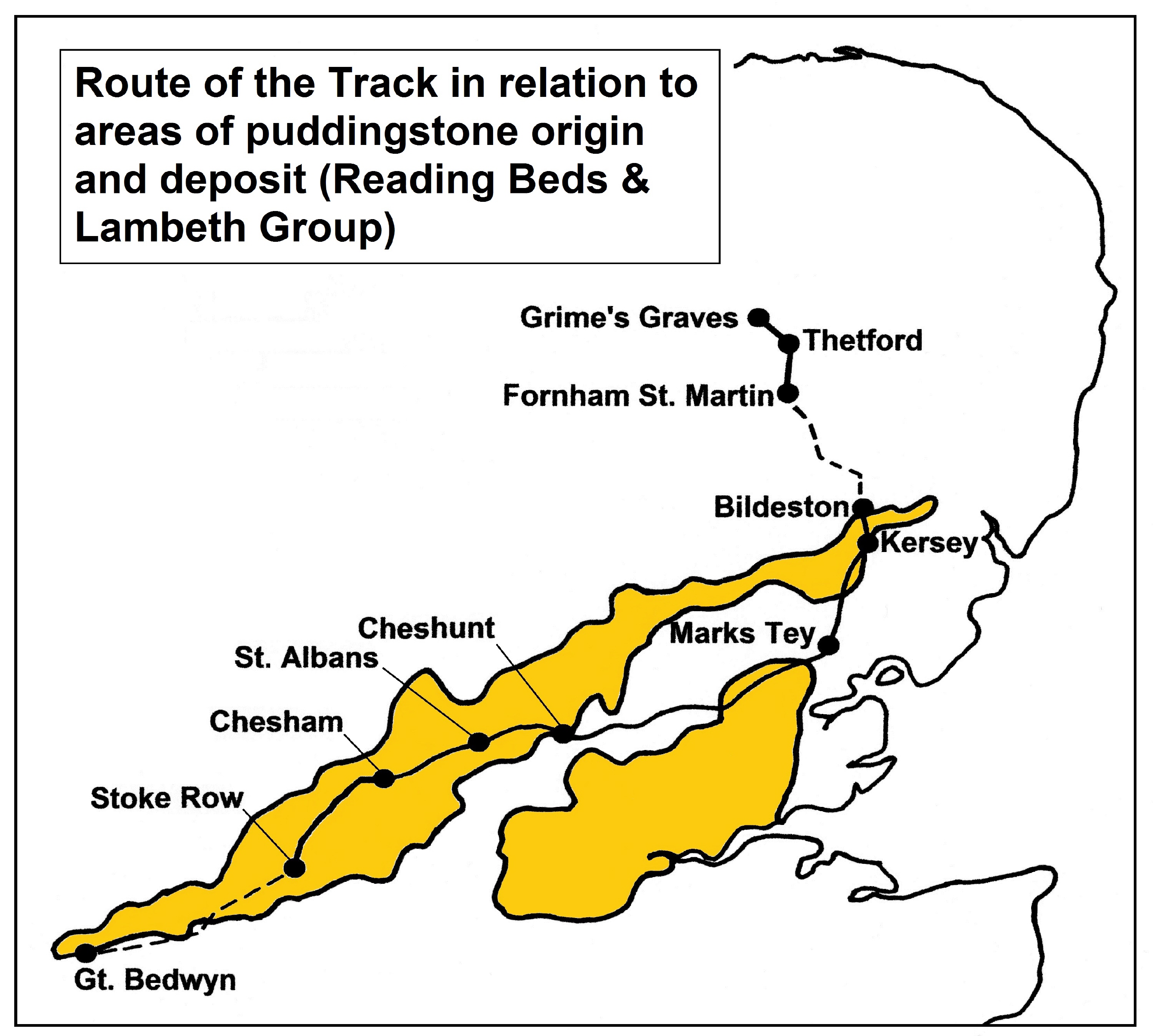
Warren pointed out that "As with igneous and other erratics, these stones were once scattered over the surface as well as buried in the glacial drifts. Clement Reid ['The Geology of the Country around Cromer', 1882] describes how the large erratic boulders have been cleared from the land and discarded in hedgerows and along the roadside, and many used as horse- or mounting-blocks, for the corner [of] walls etc. One may add that many others have also been used for more ornamental purposes, as for garden rock-work and the like. Boulders discarded along hedges, roads and boundaries will not infrequently be in alignment".2 Especially in its native Hertfordshire, the presence of puddingstone just below the soil has been a problem for farming well into the 20th century, and perhaps still is: "Each year blocks rise to the surface during ploughing and rain washes the soil particles away. Farmers, anxious to get rid of it before their equipment was damaged, would drag it to the side of the fields. Plenty of pieces lay under hedgerows, and often small pieces are found in ploughed land alongside footpaths".3 Puddingstone was sometimes used to form hand axes in both the Palaeolithic and Neolithic periods, and it was used as building material from Roman times onwards. Since at least the early 18th century small pieces of HPS have been smoothed and polished to make pendants, necklaces, brooches and cutlery handles. Landowners would use conglomerate boulders as boundary markers, wheel-guards by gateways and the corners of walls, to make grottoes and rockeries, and as ornamental monoliths for their estates. From this, the key factors to be noted are that: 1) The location of a puddingstone block now - or in Rudge's case the 1950s and 60s - is rarely any clue as to where it was 100, 500 or 5000 years earlier. 2) Like all of us, Rudge was seeing the landscape as it is 'now', with little knowledge of what has been lost from it. The map below shows how the final version of the Track (as detailed in 'The Lost Trackway') passes through the known formations in southern England where Herts Puddingstone originated or was later deposited. As can be seen, for the most part the Track travels through the regions where HPS was formed and would be expected to appear, either on the surface or just beneath it.
Immediately to the east of Cheshunt is Holyfield, and from there eastwards across Essex, the only appearances of the Reading Beds on the route occur in the form of an outlier near Chelmsford, and an apparent deposit revealed by quarrying at Little Waltham. This explains the diverse nature of the conglomerates along the Track in that county, which seems to have been a mix of HPS, ferricrete and other flinty conglomerates. The composition of 13 Essex boulders - which are either lost or currently unlocatable - was never stated by Rudge; and as noted earlier, 5 turned out not to have been conglomerates at all. Just beyond Kersey in Suffolk the Reading Beds peter out. Although small blocks of HPS have been found further north in both Suffolk and Norfolk, they're very rare. Rudge certainly never found any on his Track. While ferricrete usually has a local provenance, HPS is found east and north of its origins because of the action of rivers that no longer flow in their earlier courses. Principal among these was the Thames, which flowed in a very different course before the Anglian glaciation about 450,000 years ago. Gathering headwaters from north Wales, what is known as the proto-Thames flowed down past Oxford towards Henley, then turned north-east via Beaconsfield and Watford, and carved out what is now the Vale of St. Albans. Passing by Hertford and just north of Harlow, its course crossed Essex to Chelmsford, then ran close to Colchester before entering the North Sea basin (then Doggerland) via the Clacton area. At one point in history it was joined from the west by the extinct Bytham River, and their combined channels fanned out across Suffolk. A thick layer known as the Kesgrave Formation of sands and gravels represents the former bed of this proto-Thames, in which both puddingstone and sarsen boulders appear.
Taking all this into account, it seems that Dr. Rudge could hardly have chosen a more propitious landscape through which to chart his Puddingstone Track.
References: 1. Chris Green: 'The exploitation of silcretes (sarsen and puddingstone) in England and Normandy since Stonehenge' in 'Proceedings of the Geologists' Association' 127 (2016), p.355-6. 2. S. Hazzledine Warren: 'The Conglomerate Track' in 'Essex Naturalist' Vol.29, part 3 (1954), p.176. 3. Jean Gardner: 'Stone Age Remains in Hertfordshire' in 'Hertfordshire Countryside' Vol.44 (March 1989), p.31.
3. The Topography of the Track:
A unique feature of the Puddingstone Track is of course the supposed deliberate placing of boulders so that the prehistoric flint-trader could sight from one to the next. An obvious impediment to this would be the existence of woodland and thickets along the route. Early on, Rudge countered this with the suggestion that the Track had been set out in the drier, cooler Boreal period (which ended about 5000BC), when "the landscape was far more open than it is today".1 This would have placed its origin firmly in the late Mesolithic period, a thousand years too early to be compatible with his later theories, and he never mentioned it again.
It's now known that post-glacial Britain wasn't as densely forested as previously thought, but even intermittent woodland would still have been a major hindrance to a route that relied on sighting-points. Rudge's answer, to which he adhered throughout, was that "the entire route was designed to keep to the light, gravelly surfaces, unproductive and unprofitable for agriculture".2 According to him, the Track clung to 'gravel-capped ridges', heaths and commons for most of its length, thus traversing soils too poor, stony or acidic to sustain tree cover or any significant vegetation.
An example of this, which he called 'ideal terrain' for the traveller, would be the parish of Leavenheath in south Suffolk. He called the area "stony, arid and deserted",3 and "a desert of sands and gravels, unsuitable for agriculture".4 This must have been a surprise to the 16 working farms operating in the parish in 1958. Although some of the fields were pasture, there were extensive crops of oats, wheat, barley, beans, and later, sugar beet. Indeed the region today is still one of arable and fruit farming, dense hedgerows, grassy meadows and patches of ancient woodland. Hardly the 'arid desert' of Rudge's imagined landscape. Many if not most lowland heaths were in fact created by the clearing of woodland in Neolithic times and afterward.5 This was certainly the case with Leavenheath, whose earliest name recorded in 1290 was Levynhey, 'the enclosed wood of Leofwine'.6
There is no lack of sandy or gravelly soils across southern England. As well as glacial sands and gravels, there are the remnants of multiple river terraces, plus fluvial gravels such as the Kesgrave Formation left behind by the proto-Thames. But the Track deviates from its gravelly route when there is apparently no other option - or, less charitably, when convenient for the theory. And sometimes, Rudge is simply wrong.
For example, in 'Lost Trackway' he states "From Marks Tey an almost continuous and uninterrupted belt of glacial sands and gravels, of varying width and thickness, stretches westwards to the Essex border, and beyond into Hertfordshire; and we found that the track kept to this surface throughout." In fact, consulting the British Geological Survey's data on superficial geology, we find that this 'almost continuous belt' going westward actually peters out near Chelmsford, and the sites of only three of his Essex stones can be found upon it. Most of the surface of that county is glacial till, and the Track almost exclusively adheres to it.
Using that same BGS mapping data at the 1:50000 scale I've examined the subsoil at all 137 points on Rudge's Track. In three cases, the location given is too vague to make any conclusion. At 29 sites, there are no recorded superficial deposits at all. One of these happens to be the stone at Holyfield hamlet which started it all for Rudge, which he said stood "on a patch of river-gravel".7 Unless he always carried an auger with him for soil sampling - which he never mentioned - he was just guessing. 41 are located on deposits of sand and/or gravel, while the remaining 64 are on varieties of till, clay and alluvium.
But let's suppose for the moment that every step of the Track was indeed across poor, gravelly or acidic soil and heathland. And despite the fact that oak, birch, beech (and in prehistory, lime) are quite happy in those soils, let's also suppose that there was not a single solitary tree anywhere along its route.
The traveller trying to follow the stones would still have to deal with heather, gorse, moss, bracken, broom, thistles, brambles, ling, ferns, several types of wild grass, and many other shrubs that could reach 60cm in height or more. Too many of Rudge's Track-stones are frankly small enough that even grass only 30cm high would hide them completely.
The use of only conglomerate boulders impressed Dr. Rudge with "the ingenuity of the primitive surveyor who thus sign-posted his remarkable track in a roadless, featureless country".8 And again, with regard to central Suffolk, he called it a "featureless plain".9 Quite apart from other local Neolithic tracks that existed, the notion of a 'featureless' landscape in which his stones stood out like 'sign-posts' is a nonsense.
Putting to one side the likelihood of concealment by foliage, the practicalities of the creation and maintenance of such a Track also need to be considered. The boulders - which Rudge said would have originally numbered in the hundreds - would have had to be locally sourced. Even he didn't think that the 'primitive surveyor' "had laboriously transported his stones over ever-increasing distances".10 To be meaningful 'sign-posts' not only all other conglomerates, but all other boulders of any kind would have to be removed from anywhere near the route. Also, considering the small size of some of the stones - which even Rudge admitted "could readily be carried by one man" - there would always be a risk that some would be accidentally or deliberately moved, removed, destroyed or obscured. To the north and south of Thetford, for example, the Track passes through the sandy soils of the Brecks. Even into historical times the wind-blown topsoil would form into ever-shifting dunes, and whole communities were in danger of being engulfed by sand storms.
Apart from the nature of the subsoil, three specific topographical locations for the stones recur throughout Rudge's writings: hilltops, mounds and fords. These now need to be briefly examined.
"The track keeps to the ridges of the hill", the stones "were placed in full view upon the hilltops", and "set upon strategic sighting points such as hilltops." These are just three quotes from his early works. As time went by this concept faded into the background, but elements of it survived into 'The Lost Trackway'. Topographic mapping, however, shows that the sites of only 11 of the Track-stones can indeed be said to be on a hilltop or the crest of a ridge. (Galley Hill in Essex is a possible twelfth, but the precise location of the stone is unclear.) Rudge liked to claim that his imagined stone circle under the church at Chesham stood "on the summit of a low hill." It actually stands at an elevation of 114m, on the lower slopes of the south-eastern tip of a ridge that rises steadily to 248m in the north-west. Similarly, the most significant point on the Track through St. Albans, Rudge's 'market stone' or 'great summit stone', was supposedly on the peak of the hill upon which the city had been built. In fact the site of the stone is at 118m, while the actual summit is 500m to the NNE around St. Peter's church, at 131m.
The "necessity to see each one from the next in succession" led to the claim that "where the nature of the landscape placed difficulties in such viewing, some boulders were raised above ground level by placing them on artificial mounds".11 This was said despite the fact that he produced no evidence that any such thing had ever happened. Nowhere did he find a puddingstone on a mound, nor any record of one having been there. On the final version of his Track, he gave only three examples where he thought this had happened: Grime's Graves near Weeting (Norfolk), where there was at least a stone, supposedly rolled from a mound into a clay pit - but there's no mound at the claimed location, and no archaeological record of one; Catteshill at Great Barton (Suffolk), where no stone was found, and the mound was actually an Iron Age or Roman domestic waste heap; and Eastlow Hill at Rushbrooke (Suffolk), where again no stone was found, and the surviving mound was one of a group of four known to be Roman burial sites. It may be that, like hilltop locations, the idea of 'sighting mounds' is a hold-over from the earlier phases of his theory. He had previously cited five other such mounds - three in Essex, and one each in Hertfordshire and Oxfordshire - but they later proved inconvenient for his ever-shifting route and were abandoned. There was no puddingstone at any of them, and none could be dated to Neolithic times.
According to 'The Lost Trackway', "Rivers or streams were crossed at fords, many of which are still in use, and clearly marked with a boulder on the bank." As well as I can determine, there are at least 80 water crossings to be made along the 193 miles of the Track's course. However, Dr. Rudge only offered 11 such 'ford stones' as evidence. The most convincing of these - in that the puddingstone has survived and stands right beside a former ford - is that at Pednormead End in Chesham. At St. Albans the stone is 32m away from the still-extant ford (but with others hauled from the river bed nearby.) The stone at Kersey is right next to the ford, but isn't a conglomerate. Two others that survive also aren't conglomerate, and five are or were between 90m and 140m away from the alleged ford. In Cheshunt both ford and stone were gone before Rudge was told about them, so we only have the word of his informants as to their proximity and the stone's composition. Two occur at spots where a ford was very unlikely, one because of the water depth and steep banks, the other because of the width of the floodplain. The Mashbury puddingstone is supposed to have marked a ford over the river Can. But not only couldn't Rudge decide on its original location, it would force the traveller to double back and ford the same river twice.
It's on such flimsy evidence that Dr. Rudge's whole theory was based. He offered a few 'significant' examples - many of which don't stand up under close scrutiny - then extrapolated those to concoct an entire trackway system that to him was topographically sound, but which falls apart when reality and logic are brought into play.
References: 1. E.A. & E.L. Rudge: 'The Conglomerate Track' in 'Essex Naturalist' Vol.29, part 1 (March 1952), p.28. 2. E.A. Rudge (ed. John Cooper'): 'The Lost Trackway' (Cooper, 1994), p.22. 3. Ibid. 4. Rudge (ed. Cooper): op cit, p.13. 5. Oliver Rackham: 'The History of the Countryside' (Phoenix, 2000), p.286. 6. Keith Briggs & Kelly Kilpatrick: 'A Dictionary of Suffolk Place-Names' (English Place-Name Society, 2016), p.89-90. 7. E.A. Rudge: 'Statistical Evidence for a Conglomerate Alignment in Essex' in 'Essex Naturalist' Vol.29, part 3 (1954), p.178. 8. E.A. & E.L. Rudge: 'A Stone Age Trade Route in East Anglia' in 'Discovery' Vol.13,No.7 (July 1952), p.209. 9. Rudge (ed. Cooper): op cit, p.11. 10. E.A. & E.L. Rudge: 'The Conglomerate Track' in 'Essex Naturalist' Vol.29, part 1 (March 1952), p.24. 11. Rudge (ed. Cooper): op cit, p.22.
|
|