|
Hidden East Anglia: |
The Puddingstone Track: Deconstructed |
|
|
Puddingstone Track Deconstructed: |
Along the Track: ESSEX
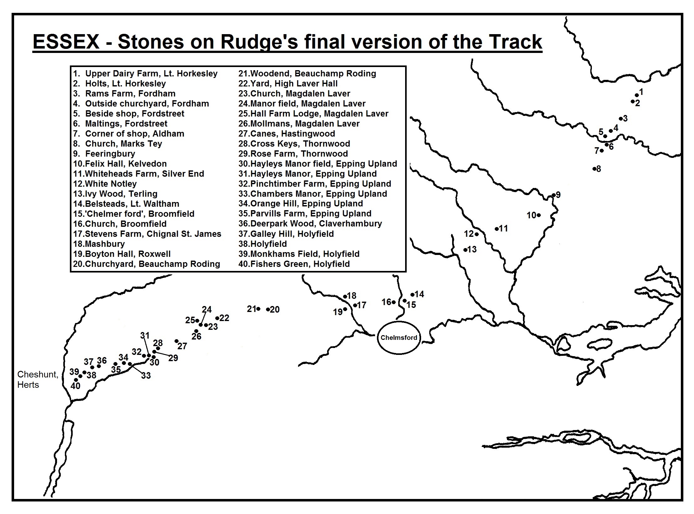
With Essex containing so many stones both on the final version of the Track and those discarded earlier, in order to make this listing more coherent I've tried to illustrate it with four additional maps. That to the left shows the first stage from the Suffolk border to Marks Tey.
Little Horkesley "At Upper Dairy Farm" (only mention 'The Lost Trackway', 1994):
1. E.A. Rudge (ed. John Cooper): 'The Lost Trackway' (1994), p.13.
Little Horkesley "At Holt Farm" (only mention 'The Lost Trackway', 1994): 350m further south along the same road is the former Holt Farm, now known simply as Holts. The 15th century farmhouse survives in its secluded, tree-shrouded setting, but the site, as is common today, is now a collection of residential homes (TL94853115.) Rudge gave no information whatsoever about the stone said to be here, nor any clue as to where it might be found. The next point on his Track is just over 1½ miles SSW of here.
Wakes Colne (NOT ON FINAL VERSION OF TRACK) "At Crepping Hall" (only mention 1957): This site was part of the route when Dr. Rudge thought his Track took a ridiculous diversion south-westwards to Bures in Suffolk, then south across the river Stour to Wakes Colne. After that it supposedly went south-east to the crossing of the Colne at Fordstreet (ignoring two boulders that he already knew about at Fordham.) "Boulders have been reported at Crepping Hall" was apparently all he needed to include this location.1 But like the Bures stone, this was soon discarded and never mentioned in print again. Perhaps there were indeed puddingstones somewhere in the ten acres of meadow, garden and manicured lawn at Crepping Hall (TL90942845) - but if so, they don't seem to have been recorded before or since.
1. E.A. Rudge: 'The Puddingstone Track' in 'Essex Naturalist' Vol.30 (1957), p.54.
Fordham "Rams Farm stone" (first mention in print 1952; read to the EFC 1951):
1. E.A. & E.L. Rudge: 'The Conglomerate Track' in 'Essex Naturalist' Vol.29, part 1 (March 1952), p.30 (read 24/11/51.) 2. E.A. Rudge (ed. John Cooper): 'The Lost Trackway' (1994), p.13.
Fordham "Roadside by church - unconfirmed" (first mention in print 1950; read 1949): A little less than three-quarters of a mile SSW of Rams Farm is All Saints church. The puddingstone here was said to be "buried and hidden in a grass-bank beside the church".1 Although he never saw it, three people separately told him that it was there. It was later said to be by the south side of the churchyard gate.2,3 This would place it at c.TL92772807. I examined this grassy bank in July 2016 and probed the ground with steel rods, but detected nothing. Rudge claimed that this stone, then exposed, had been previously misidentified as a sarsen.4 In this he was referring to A.E. Salter's list of Essex boulders published in 1914, where it was described as a three foot long sarsen in the roadside bank.5 This was recorded by a recognised geologist who saw it, whereas Rudge did not, so it has to be accepted that this was NOT a puddingstone. In support, there are also two other sarsens of decent size built into the church walls.
1. E.A. & E.L. Rudge: 'Evidence for a Neolithic Trackway in Essex' in 'Essex Naturalist' Vol.28, part 4 (March 1950), p.178 (read 29/10/1949.) 2. E.A. & E.L. Rudge: 'The Conglomerate Track' in 'Essex Naturalist' Vol.29, part 1 (March 1952), p.30 (read 24/11/51.) 3. E.A. Rudge: 'The Statistical Evidence for a Conglomerate Alignment in Essex' in 'Essex Naturalist' Vol.29, part 3 (1954), p.185. 4. Op cit, p.180. 5. A.E. Salter: 'Sarsen, Basalt and Other Boulders in Essex' in 'Essex Naturalist' Vol.17 , parts 10-12 (August 1914), p.196.
Fordstreet (Aldham) "Embedded beside shop" (first mention in print 1950; read 1949):
1. E.A. & E.L. Rudge: 'Evidence for a Neolithic Trackway in Essex' in 'Essex Naturalist' Vol.28, part 4 (March 1950), p.178 (read 29/10/1949.) 2. E.A. & E.L. Rudge: 'The Conglomerate Track' in 'Essex Naturalist' Vol.29, part 1 (March 1952), p.30 (read 24/11/51.) 3. E.A. Rudge (ed. John Cooper): 'The Lost Trackway' (1994), p.14.
Fordstreet (Aldham) "Garden of Maltings" (first mention in print 1952; read 1951): Staying in Fordstreet, 120m further south along the main road is a 16th century house, once an inn, called The Maltings (TL92092688.) Here, said Rudge, was a "large stone" in the back garden.1 In 2008 a contributor to the 'Megalithic Portal' website said that they had gained permission to see this stone, and reported that it was then part of a rockery. They described it as a roughly egg-shaped, dark brown conglomerate (almost certainly ferricrete, not true puddingstone), and only about "a foot or so" (30cm) in size.
1. E.A. Rudge (ed. John Cooper): 'The Lost Trackway' (1994), p.14.
Aldham "Corner of small shop" (only mention 'The Lost Trackway', 1994): Even in the 19th century, Aldham was a parish of widely-scattered houses, with the main area of habitation further north, clustered around the bridge at Fordstreet. There was no Aldham village at all until the 20th century, with new building taking place between the 1920s and 1960s around the 1854 church. According to Dr. Rudge, the direction of his Track went south from Fordstreet, across Gallows Green, and through Aldham village three-quarters of a mile away, "where a boulder is built into the corner of a small shop".1
Try as I might, I cannot trace where this shop might have been. According to the only history of Aldham ever published2 there have never been any shops in the village. At Fordstreet certainly, and there was an off-licence/grocers at Gallows Green that closed in 1961 - but nothing is recorded in the village itself.
1. E.A. Rudge (ed. John Cooper): 'The Lost Trackway' (1994), p.14. 2. Angela Green: 'Aldham, Essex' (Green, 2004.)
Aldham (NOT ON FINAL VERSION OF TRACK) "Rockery at Crape's Farm" (only mention in print 1950; read 1949): Crapes Fruit Farm as it now is can be found at TL91522527, about a third of a mile SSW of the village, on Rectory Road. In Rudge's day it was also a plant nursery. Here he described the stone as "fragments distributed over the rockery".1 No rockery exists there today. Despite the fact that it continued to be on the 'correct' alignment for his Track, he quickly dropped it as a marker-point. Fragments on a rockery could of course have come from anywhere, and he had no evidence that they were ever part of a single stone. Unfortunately, he continued to accept rockery stones along other sections of his trackway.
1. E.A. & E.L. Rudge: 'Evidence for a Neolithic Trackway in Essex' in 'Essex Naturalist' Vol.28, part 4 (March 1950), p.178 (read 29/10/1949.)
Marks Tey "North wall of church" (first mention in print 1950; read 1949):
Dr. Rudge was always
especially pleased to encounter conglomerates built into the fabric of
churches, considering them 'pagan' stones that indicated ancient sites, thus
demonstrating the antiquity of his Track. But as he said, "The 'pagan' stone
must not be confused with stones and boulders employed in general
construction". He pointed out that local conglomerates are often used in
Ironically, the inclusion of this church on his Track on the very next page of his article completely tramples all over his own argument. Not only is his chosen stone flush with the wall and in no way notable, but exactly the same ferrous conglomerate is used extensively in the facing of the rest of the church, particularly in the nave, chancel and tower on the south and west sides (as shown in the second photograph.)
1. E.A. and E.L. Rudge: 'A Stone Age Trade Route in East Anglia' in 'Discovery' magazine Vol.13, No.7 (July 1952), p.209. 2. E.A. Rudge: 'The Statistical Evidence for a Conglomerate Alignment in Essex' in 'Essex Naturalist' Vol.29, part 3 (1954), p.185. 3. Op cit, p.184.
Second stage, Feering to Roxwell.
Feeringbury (Feering) "Beside house, Feeringbury" (first mention in print 1950; read 1949):
As I remarked above, at
Marks Tey the Track turns sharply south-west, and 3½ miles later arrives at
Feeringbury, a manor house and farm dating back to the 13th century. "Here",
said Rudge, "a large boulder, half-buried, marks the crossing of the River
Blackwater...The Feeringbury stone is incongruously situated next to a
modern petrol pump, supplying the local farm".1 After
A vintage petrol pump - though a later one than was there in Rudge's time - still stands close by. The boulder itself is a dark brown ferruginous conglomerate, 100cm x 70cm x 40cm high, and well-embedded. The river Blackwater flows along the bottom of the Manor gardens, but the idea that the stone marked a ford crossing here is very unlikely. Although the river isn't very wide at this point, the banks are quite steep, and even now there are signs along them saying 'Beware - deep water'. Also, Dr. Rudge failed to mention the equally-embedded and somewhat larger sarsen boulder even closer to the river within the gardens.
1. E.A. Rudge (ed. John Cooper): 'The Lost Trackway' (1994), p.14.
Kelvedon "At Felix Hall" (only mention 'The Lost Trackway', 1994): "A stone has been reported at Felix Hall, well-known to local villagers, but unconfirmed".1 Despite having so little information, Rudge nevertheless chose to include this site on his Track. The Hall was an 18th century country mansion set within its own wooded park land about a mile west of Kelvedon, and just over 1½ miles south-west of Feeringbury. It was badly damaged by fire in 1940, leaving the main building a shell. It has lately been renovated and is partially habitable, with a number of separate buildings now apartments and private residences. Of the stone, I can find no other report.
1. E.A. Rudge (ed. John Cooper): 'The Lost Trackway' (1994), p.14.
Cressing (NOT ON FINAL VERSION OF TRACK) "Cressingtemple, buried" (only mention in print 1950; read 1949): Someone apparently reported a boulder here to Rudge, who listed it as "buried; unconfirmed". The map reference given was TL805187, which points to an arable field about 280m due east of Cressing Temple Barns. This is one of half a dozen sites that he recorded as being on the Track in his first paper on the subject, but very soon dropped and never mentioned again. It's also the first of five sites in this part of Essex (C - G on the 'Feering to Roxwell' map) where his discarded stones form a 10 mile long 'track' almost parallel to the final version. The sequences C - G and 11 - 17 start and end at almost the same places.
Silver End "Whiteheads Farm, buried in yard" (first mention in print 1952; read 1951): 2½ miles WSW of Felix Hall we reach Whiteheads Farm (TL80861794), where only the top of a boulder could be seen, near a cattle pen in the farmyard.1 Any trace of this has long gone - there are no more cattle pens here, and all the yards have been resurfaced.
1. E.A. Rudge (ed. John Cooper): 'The Lost Trackway' (1994), p.14.
White Notley "Roadside opposite Pink Lane" (first mention in print 1950; read 1949): The boulder here is probably the most well-known puddingstone in Essex. It's also what 'true' Hertfordshire Puddingstone is supposed to look like, as opposed to many of Rudge's examples. It can be found 1¼ miles west of Whiteheads Farm, on the north side of the road called Church Hill that leads south from White Notley village. More specifically, it's at TL7880717722, on the verge outside Forge Cottage, close to the start of a footpath that leads past Whiteways to a footbridge (and ford) across the little 'river' Brain. Rudge said that "Opposite the stone is Pink Lane, leading to Ivy Wood", where he believed there was another boulder.1 However, the junction with Pink Lane (an old farm track, now concreted) is actually 79m further south, and the lane goes nowhere near Ivy Wood.
In 'Lost Trackway', Dr. Rudge admitted that the next section, between White Notley and the river Chelmer, had been "the most difficult to unravel." Before he decided that the Track went on in a SSW direction, he thought it went more south-westerly, and so included three other stones that he later discarded, which will be examined next.
1. E.A. Rudge (ed. John Cooper): 'The Lost Trackway' (1994), p.14. 2. 'Essex Naturalist' Vol.1, No.1 (Jan. 1887), p.8.
Fairstead (NOT ON FINAL VERSION OF TRACK) "Base of church tower" (first mention in print 1950; read 1949):
With the cement facing gone I could also see seven other masses of the same rock set into the fabric just above ground level - not just on the north, but on all three sides of the tower (bottom photo.) The main conglomerate is another of what Rudge called his 'pagan' stones, but all are surely no more than locally-sourced rocks used as free building material.
1. E.A. & E.L. Rudge: 'The Conglomerate Track' in 'Essex Naturalist' Vol.29, part 1 (March 1952), p.30 (read 24/11/51.) 2. E.A. Rudge: 'The Statistical Evidence for a Conglomerate Alignment in Essex' in 'Essex Naturalist' Vol.29, part 3 (1954), p.185.
'Confirmatory evidence' (NOT ON FINAL VERSION OF TRACK) Fuller Street, Great Leighs "sunken road": Rudge gave a map reference of TL740160, which lands beside a lane called Cole Hill, a little west of Fuller Street. He described here a "sunken road" that he felt was on the line of his Track - but he also said that it was "parallel to the modern road".1 He can only have been referring to what is actually a ditched field boundary that does indeed run parallel to, and 30m from, Cole Hill - but both run north-south, completely contrary to his supposed Track route, which at this stage was still heading in a SSW direction. The only reason I can see for it is a sudden and unnecessary deviation to cross the river Ter and reach his next stone, at Great Leighs church.
1. E.A. & E.L. Rudge: 'Evidence for a Neolithic Trackway in Essex' in 'Essex Naturalist' Vol.28, part 4 (March 1950), p.175 (read 29/10/1949.)
Great Leighs (NOT ON FINAL VERSION OF TRACK) "In Saxon wall of church" (first mention in print 1950; read 1949):
No part of St. Mary's
church (TL73841559) is demonstrably Saxon. The oldest parts are the nave and
circular tower, which date to the late 12th century. In 1952 Rudge seemed to
refer to a single stone in the "North wall of round tower".1 But
his last mention two years
1. E.A. & E.L. Rudge: 'The Conglomerate Track' in 'Essex Naturalist' Vol.29, part 1 (March 1952), p.30 (read 24/11/51.) 2. E.A. Rudge: 'The Statistical Evidence for a Conglomerate Alignment in Essex' in 'Essex Naturalist' Vol.29, part 3 (1954), p.185.
Howe Street (Great Waltham) (NOT ON FINAL VERSION OF TRACK) "At River Chelmer ford" (first mention in print 1952; read 1951): Until he decided otherwise, the hamlet of Howe Street is where Dr. Rudge originally thought that his Track crossed the Chelmer, with "the ford stone still lying in the yard of Rectory Farm".1 This is no longer a working farm but a private residence with extensive lawns and wooded grounds, and the waters of the Chelmer lap at the boundary walls (TL70021472.) I've been unable to determine if any boulder still exists on the site.
1. E.A. & E.L. Rudge: 'The Conglomerate Track' in 'Essex Naturalist' Vol.29, part 1 (March 1952), p.23 (read 24/11/51.)
Ivy Wood (Terling) "Beside footpath in Ivy Wood" (only mention 'The Lost Trackway', 1994): 1¼ miles from White Notley, a path in the western part of Ivy Wood was, according to Rudge, 'reputed' to have a puddingstone boulder beside it (TL778162.) Although the manuscript of his book contains the only mention of it by the man himself, he knew about it as far back as 1952. In the enthusiasm of the early years of his theory, he conducted several 'motor coach' trips for members of the Essex Field Club (plus guests) whereby they could see some of his stones and learn more about the Track. One such trip took place on September 13th 1952, involving 30 people on the coach, with others joining later by car. The notes of that outing say that "After crossing the River Ter at Terling Ford, Dr. Rudge put the 'pack' in to draw Ivy Wood near Great Loys Farm. He had hopes of locating a great 'block of concrete' said to lie in the wood and which may prove to be another track-stone, but, in spite of members' enthusiasm, nothing was found".1 So it seems that, despite never locating or seeing it, and never knowing if it was actually puddingstone or old concrete, Dr. Rudge still chose decades later to include this point on the final version of his Track. The western part of Ivy Wood covers about 25 acres and measures c.400m from north to south; so even if it existed and was a conglomerate, the stone could have been a considerable distance from the Track's course.
1. 'Reports of Meetings' in 'Essex Naturalist' Vol.29, part 2 (1953), p.123.
Little Waltham "At Belsteads" (first mention 1955): Now the projected route of the Track shifts back to a south-westerly direction, and there is a gap of 4½ miles from Ivy Wood to this point. On the same Field Club outing in 1952 mentioned above, Dr. Rudge showed the members "a fine track-stone which he had discovered only the previous month." This was beside the 15th century former farmhouse called Belsteads at TL72361129, just over a mile south-east of Little Waltham village. In articles of 1955 and 1957 he mentioned it in passing, and finally in 'Lost Trackway' he simply said that it was a "large boulder" in the garden. I went there in June 2017, but there was no sign of any boulder.
1. A.E. Salter: 'Sarsen, Basalt and Other Boulders in Essex' in 'Essex Naturalist' Vol.17, parts 10-12 (August 1914), p.193.
Broomfield "Boulder marking ford" (only mention 'The Lost Trackway', 1994): It's very unlikely that there was ever a ford at Broomfield in prehistoric times. The wide shallow valley of the river Chelmer here is a grassland floodplain, and there was a known ford at Chelmsford only 2½ miles away. But Rudge felt sure there was a crossing point here, three-quarters of a mile south-west of Belsteads, which had been lost due to the construction of a watermill. He gave a map reference of TL715105 for a puddingstone which he said used to mark this crossing. This places it on that floodplain, a little east of the river and north of the mill. And it was another stone that he never saw, as it had allegedly been broken up 'recently' and its material used in making a lane to the mill. Just how 'recent' the local memory was is debatable, as the last watermill on this site was demolished in 1919. But the engine house survived until 1945, and the miller's house still stands, so perhaps that is what was being referred to.
Broomfield "In south wall of church" (first mention 1952):
Just half a mile west
across the river is the church of St. Mary with St. Leonard in Broomfield,
and another of Rudge's 'pagan'
Chignal Smealy (NOT ON FINAL VERSION OF TRACK) "In farmyard, Langley's Farm" (first mention in print 1952; read 1951): This is the last stone in Rudge's abandoned sequence (C - G on the map) when he thought the Track went via Fairstead, Great Leighs and Great Waltham. He gave a map reference of TL664113 for Langley's Farm, which is on Mashbury Road, but no further details of the stone. The site has changed a lot since Rudge's time, with many new buildings and yard surfaces. The farm is now home to an agricultural machinery company, and there is no trace of a puddingstone.
Chignal St. James "At Stevens Farm" (first mention 1957): Two miles west of Broomfield is Stevens Farm, now a private house, with barns and cart lodges converted to office use. The stone here gained only a passing mention by Rudge in a 1957 article, but as at Terling and Little Waltham, he brought the Essex Field Club members here on their outing in September 1952. According to the report, the party "moved on to the roadside stone marking the ford over the River Can at the rear of Stevens Farm".1 Rudge later wrote that this "large boulder was found in an adjacent field and now rests beside the gate of Stevens Farm".2 He failed to say where this "adjacent field" was, but it could perhaps have been the field c.110m south-west of the farm, where there was indeed a ford across the little river, now replaced by a footbridge.
1. 'Reports of Meetings' in 'Essex Naturalist' Vol.29, part 2 (1953), p.123. 2. E.A. Rudge (ed. John Cooper): 'The Lost Trackway' (1994), p.14.
Mashbury "At Mashbury Hall" (first mention in print 1950; read 1949):
This next stone makes
absolutely no sense with regards to the direction of Rudge's Track. When he
first spoke of it in 1949, it was in the farmyard at Mashbury Hall, but it
had been "moved 200 yards [c.183m] north" to be at that point.1
That would mean it had
Since Broomfield, the
direction of the Track has been westerly, and will continue so for a while.
If the puddingstone at Stevens Farm in Chignal St. James is on the Track, as
well as the next at Roxwell's Boyton Hall (which is not much more than half
a mile away), then Mashbury can't be. ANY of the locations given for the
stone mean that Rudge's prehistoric traveller would cross the river Can at
The stone itself still exists at TL6512011785, on a grassy sward at the southern tip of a large pond in the grounds of the Hall (a possibly 17th century country house, now home to a livery yard.) This is a true Herts Puddingstone approx. 3'6" x 3' x 2' (107cm x 92cm x 61cm), whose dimensions were recorded by Miller Christy and published by Salter in his 1914 paper.4 Unfortunately I was unable to gain access to it when I visited in June 2017, as the privacy of the Hall grounds is guarded by electronic gates and CCTV, so the photo is Dr. Rudge's original.
1. E.A. & E.L. Rudge: 'Evidence for a Neolithic Trackway in Essex' in 'Essex Naturalist' Vol.28, part 4 (March 1950), p.175 (read 29/10/1949.) 2. E.A. & E.L. Rudge: 'The Conglomerate Track' in 'Essex Naturalist' Vol.29, part 1 (March 1952), p.23 (read 24/11/51.) 3. E.A. Rudge (ed. John Cooper): 'The Lost Trackway' (1994), p.14. 4. A.E. Salter: 'Sarsen, Basalt and Other Boulders in Essex' in 'Essex Naturalist' Vol.17, parts 10-12 (August 1914), p.193.
Roxwell "At Boyton Hall" (first mention 1954): Ignoring the Mashbury nonsense, two-thirds of a mile west of Stevens Farm was what Dr. Rudge called "probably the largest puddingstone boulder of all".1 Boyton Hall (TL65670974) was and still is a farm, although nowadays it is home to a business park as well. It was also another stop on the 1952 outing for the Essex Field Club, where "in the yard, they saw the large boulder of ferruginous conglomerate and, in the garden, what was called the 'rockery', made up for the most part of conglomerate stones".2 And once again, Miller Christy in the early 1900s recorded its dimensions, which he said were 5'-6' x 4' x 3' (1.5-1.8m x 1.2m x 92cm).3
So, in addition to the main boulder, there was a rockery composed mainly of conglomerates. Christy also saw in the farmyard boulders of sandstone, sarsen, breccia (another type of conglomerate) and limestone. This suggests a local source for all these rocks - and indeed there was one. 500m NNE of the farm was a gravel pit that had been there since at least the 18th century. Over time it developed into Roxwell Quarry, which only ceased operations in recent years. In 1889 it was noted that in this very pit "great masses of conglomerate occur, some of them so large as to be immovable by ordinary means...Several large blocks, 4 to 5 feet in diameter and 2 to 3 feet thick, have been removed at different times to form rockeries etc".4 Rather than being a relic of any prehistoric trackway, Rudge's boulder at Boyton Hall was probably just dug up in post-medieval times like all the others.
Dr. Rudge was very familiar with Salter's paper on Essex boulders, which makes his omission of another nearby stone rather suspicious. Just over 1½ miles south-west of the Hall at Stonehill Farm could be found a block of Herts Puddingstone - again recorded by Christy and listed by Salter. But of course, that would have once more thrown off the line of his Track.
In 2017 I contacted the owners of Boyton Hall to see if the large conglomerate there still existed. Unfortunately there is now no trace of it, and even their own enquiries among local people failed to unearth any knowledge of it.5
1. E.A. Rudge (ed. John Cooper): 'The Lost Trackway' (1994), p.14-15. 2. 'Reports of Meetings' in 'Essex Naturalist' Vol.29, part 2 (1953), p.123. 3. A.E. Salter: 'Sarsen, Basalt and Other Boulders in Essex' in 'Essex Naturalist' Vol.17, parts 10-12 (August 1914), p.192. 4. Reginald W. Christy: 'Notes on the Geology of the District around Chelmsford' in 'Essex Naturalist' Vol.3 (July-Sept 1889), p.172. 5. Information from Chris Philpot of Boyton Hall Farm, 25/1/2017.
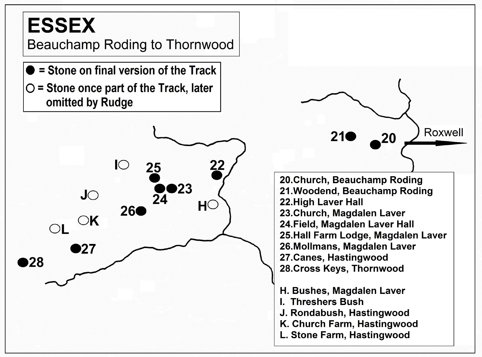
Third stage, Beauchamp Roding to Thornwood.
Beauchamp Roding "In Beauchamp Roding churchyard" (first mention in print 1950; read 1949):
Continuing on its westward
course, after almost five miles with no new mark-stones, the Track reaches
St. Botolph's church at Beauchamp Roding, isolated in fields without any
village around it. The roughly-triangular, sharp-edged stone can be found at
TL5780609727, close to the north-east corner of the church. For a number of
years Rudge seems to have been confused about where it was, however. In 1951
he said it was south-west of the church, and in 1954, south-east, before
finally settling on the correct location in 'Lost Trackway'. When he saw it,
it was lying flat on the ground, with no sign that it had ever been
embedded. But apparently in 1984 it was surreptitiously set upright in the
earth by a group calling themselves the 'Markstone Liberation Front'. It was
The important thing about this boulder is that it's NOT puddingstone. It is in fact a plain sarsen with just a short line of pebbles inset along one narrow edge, and two or three more pebbles visible on one of the wider surfaces. Since the whole point of using conglomerate boulders on the Puddingstone Track was, according to Rudge, that they should be "recognisable as such without the slightest hesitation",2 one has to wonder how confused the prehistoric traveller would have been when they saw this one.
Dr. Rudge obviously regarded this as another 'pagan' stone, given its location in the churchyard. This feeling was enhanced by a legend told to him by locals. The church is isolated, and on rising ground, but the legend says that it was meant to be built down in the nearby valley. The villagers wanted to use this stone in its construction, and dragged it down the hill – but next morning found it back on the high ground. This happened twice more, until they gave up and decided to build the church on the heights, next to the stone. Variations on this tale are told all over the country to explain the sites of churches and other buildings, and Rudge (without evidence) thought them suggestive of a "pre-Saxon antiquity." Try as I might, I've been unable to find any earlier record of this particular story, so it seems that Rudge himself was the first to commit it to print, in 1950.
1. A.E. Salter: 'Sarsen, Basalt and Other Boulders in Essex' in 'Essex Naturalist' Vol.17, parts 10-12 (August 1914), p.190. 2. E.A. Rudge (ed. John Cooper): 'The Lost Trackway' (1994), p.9.
Beauchamp Roding "At Woodend Farm" (only mention 'The Lost Trackway', 1994): For some reason, after continuing in a westerly direction for some miles, here Rudge decided that his Track made a half mile detour to the north-west. If his map reference of TL572102 is accurate, the boulder here was found in 1944 in a field about 150m east of 16th century Woodend Hall. There is no farm anymore, just the old farmhouse and an isolated group of high-end barn conversions along a dead end lane, which collectively seem to be called Woodend. One of the homes on the site is named Woodend Barn, which was on the market in 2015. I found estate agency photographs showing a boulder in the garden just beyond the patio, at TL5702410240, but it's impossible to tell what kind of stone it is. I visited Woodend in the summers of both 2017 and 2018, but couldn't find anyone of whom I could make enquiries, and the tall driveway gates were all locked.
High Laver "In farmyard, broken in fragments" (first mention in print 1950; read 1949):
From Woodend to High Laver
church is about three miles in a south-westerly direction. Rudge said that
the stone here "lies in fragments in the yard of the Grange Farm next to the
church". He was told by a farmer who lived two miles away that it was once
1. E.A. & E.L. Rudge: 'Evidence for a Neolithic Trackway in Essex' in 'Essex Naturalist' Vol.28, part 4 (March 1950), p.177 (read 29/10/1949.) 2. E.A. & E.L. Rudge: 'The Conglomerate Track' in 'Essex Naturalist' Vol.29, part 1 (March 1952), p.23 (read 24/11/51.) 3. E.A. Rudge (ed. John Cooper): 'The Lost Trackway' (1994), p.3.
'Confirmatory evidence' (NOT ON FINAL VERSION OF TRACK) "High Laver Mound" (only mention in print 1952; read 1951): As at Catteshill and Eastlow Hill in Suffolk, and a supposed mound near Grimes Graves, Dr. Rudge included this location on his Track (briefly) with the thought that it had been erected in prehistory as a sighting-point on which a now-vanished puddingstone had once been placed. This mound is at TL5270108412, about 300m south of High Laver church. It's basically a tree-shrouded 'hump' 46m across and about 3.5m high, with a ditch around it. The old field names here were Mount Mead and Mill Hill, and it's recorded archaeologically as "a typical moated mill mound".
Magdalen Laver (NOT ON FINAL VERSION OF TRACK) "At Bushes" (only mention 1957):
Even further south is the
old moated farmstead called Bushes, where Rudge said another
1. Jacqui Farrants and Paul Bentley: 'Puddingstone Walks in Essex' (Half Way Publishing, 2018), p.130-1.
'Confirmatory evidence' (NOT ON FINAL VERSION OF TRACK) "Pole Lane Mound, Magdalen Laver" (only mention in print 1950; read 1949): On the earliest version of Rudge's route for the Puddingstone Track was another site commonly accepted to be a moated mill mound, but which may actually be something more. This one stands at TL51590843, and is shown on Chapman and André's Essex map of 1777. Completely cloaked by trees, it can be found beside an old track called Pole Lane - which some have said used to be the main street of a village that became deserted during the Black Death, but there's no evidence of any lost settlement here. In fact the track may be all that remains of an old boundary bank. The mound itself is 36m in diameter and c.4.5m high, but a digital survey has shown that it has been recapped at some time. Two archaeologists from English Heritage have in recent years investigated it, concluding that it may in fact be a Bronze Age barrow, dating from c.2200-1800BC, but reused as a mill site in the Middle Ages.1
1. Peter Sharp and David McOmish: 'Survey of an earthwork mound - Magdalen Laver' in 'Transactions of the Essex Society for Archaeology & History' 4th Series, Vol.4 (2013), p.223-7.
Magdalen Laver "At base of northern church wall" (first mention in print 1950; read 1949):
1. E.A. & E.L. Rudge: 'Evidence for a Neolithic Trackway in Essex' in 'Essex Naturalist' Vol.28, part 4 (March 1950), p.177 (read 29/10/1949.) 2. E.A. and E.L. Rudge: 'A Stone Age Trade Route in East Anglia' in 'Discovery' magazine Vol.13, No.7 (July 1952), p.207. 3. Jacqui Farrants and Paul Bentley: 'Puddingstone Walks in Essex' (Half Way Publishing, 2018), p.125.
Magdalen Laver "Manor stone, in field west of church" (first mention in print 1952; read 1951): The given map reference of TL512083 places it in a heavily wooded field that is part of the grounds of Magdalen Laver Hall, and which contains traces of the earthwork remains of the original Norman manor house. The puddingstone somewhere on this private land is even bigger than the one at Roxwell, measuring 2m x 1.5m x 40cm. Nearby is a sarsen rock 90cm x 60cm. It seems that "The lower half of the puddingstone contains no pebbles and is therefore similar to a sarsen".1 Some of the manorial earthworks would appear to have been lost to quarrying in this field at some point in history - which could of course be the origin of these boulders.
1. Gerald Lucy: 'Essex erratic boulders: a gazetteer' in 'Essex Naturalist' New series No.20 (2003), p.126.
Magdalen Laver "In ditch near Manor Farm gate" (first mention 1954):
Threshers Bush (High Laver) (NOT ON FINAL VERSION OF TRACK) "Thrushesbush" (only mention 1954) This begins another short sequence of stones that parallels the final Track for just over four miles (I - L on the Beauchamp Roding to Thornwood map), and heads for the same point, Cross Keys at Thornwood. Like the earlier discarded stretch from Cressing to Chignal Smealy, it highlights the fact that Rudge himself was sometimes misled by a divergent line of boulders. If his theory had been correct, exactly how was the prehistoric traveller supposed to navigate the correct route with two directions to choose from? These and other such diversions yet to come make a nonsense of his own statements about the Track, firstly in 1952: "nowhere have we found any trace of side-branches"; in 1954: "nowhere have we discovered branching trails or duplicated tracks"; and in 1957: "no branching trail of similar boulders has yet been found."
Nowadays this crossroads with a few old farmsteads around it is known as Threshers Bush, and is just under a mile north-west of the previous stone at Magdalen Laver. Only two facts are given about the puddingstone said to have been here, both map references. Its position in 1954 was stated to be TL499093, but it was "taken from TL499091".1 Six-digit references aren't very accurate of course, but looking at the 1946 One Inch map that Rudge would have used, the first location is plainly meant to be in the yard of Bush Hall Farm, in the eastern angle of the crossroads. The second location is in an unremarkable field about 100m south of the farm. As is common, Bush Hall isn't a farm anymore. The whole site has been converted from barns, maltings etc into residential homes. I could see in 2017 that the yards are now bare gravel, or transformed into gardens, and the stone seems to have gone.
In 1996 Terry Johnson said that at the crossroads "a small reddish stone is embedded in the earth bank".2 It's probably unconnected with the Track, but there's no sign of such a stone there now.
1. E.A. Rudge: 'The Statistical Evidence for a Conglomerate Alignment in Essex' in 'Essex Naturalist' Vol.29, part 3 (1954), p.180. 2. Terry Johnson: 'Hidden Heritage: Discovering Ancient Essex' (Capall Bann Publishing, 1996), p.165.
Hastingwood (North Weald) (NOT ON FINAL VERSION OF TRACK) "Garden of 'Rondabush', Hastingwood" (first mention in print 1952; read 1951): Staying with this divergent route, just over a mile south-west of Threshers Bush is the hamlet of Hastingwood. The boulder here was only ever mentioned twice, and both times Rudge called it the 'Black Cottage stone', with no explanation. 'Rondabush' is a 20th century detached house on Mill Street, at TL4867808034. Beside it runs a footpath that heads for a footbridge over a tiny stream that is a tributary of the little Shonks Brook. In 1954 Rudge said that this stone in the garden was "Beside footpath".
I visited the house in September 2016 and spoke with the owner. He knew of puddingstone, but said there was no boulder in his garden. The house had been rebuilt 17 years previously, so he suggested that perhaps the builders had buried the stone beneath the new patio, or had thrown it into the old well which they had filled in, the outline of which was still visible in the lawn. He had intended to dig out the well, so I left my contact details should he uncover the stone - but I've never heard anything further. The owner also told me that the land on which his house stood once belonged to Nightingale Cottage, which is 70m away, just beyond the little stream (although the 1849 tithe map indicates otherwise.) It's possible that in the early 1950s it was called 'Black Cottage', but I've found no evidence of it.
Hastingwood (North Weald) (NOT ON FINAL VERSION OF TRACK) "Church Farm, by gate to field" (first mention 1954): About a third of a mile south now from 'Rondabush', still on the divergent Track, we reach Church Farm House, all that is left of the original late 19th century farm. Rudge's map reference of TL486075 actually points to a spot behind the farmhouse, on the lane to Paris Hall. The piggery that stood here in the 1950s has long gone, as have any field gates, and any puddingstones. Now the area is a concentration of business units and a large concreted parking space.
Hastingwood (North Weald) (NOT ON FINAL VERSION OF TRACK) "At Stone Farm" (first mention in print 1952; read 1951): The most that Dr. Rudge ever wrote about this mark-point was "at Stone Farm - now ruined - has not been found".1 He had no evidence that any puddingstone ever existed here, simply making an assumption based on the name of the farm, and the fact that it was on the then-favoured line of his Track. This was close to half a mile south-west of the previous stone, at TL47910708.
Also once known as Baldock's Farm, the buildings were already in ruins by the late 1940s, and were soon after demolished. By 1973, there was a new farmhouse on the site, called Stone Barton, but in 1990 that was replaced by the St. Clare Hospice. It stands next to Hastingwood Roundabout, that was part of the construction of Junction 7 on the M11 in the 1970s.
1. E.A. Rudge: 'The Statistical Evidence for a Conglomerate Alignment in Essex' in 'Essex Naturalist' Vol.29, part 3 (1954), p.180.
Magdalen Laver "Outside Mollman's Farm" (first mention in print 1950; read 1949):
Here we are half a mile
south-west of the Hall Farm stone in this parish, and back on the final
version of the Track. Tilegate Road meets the road to Hastingwood at a
three-way junction often known as Mollmans Corner. It's named after the 16th
century former farmhouse called Mollmans opposite the junction. Dr. Rudge
was told that a large, conical puddingstone used to stand on the roadside
verge in front of the house, but that a previous owner had "removed it as an
obstruction to farm traffic." It was broken in the process, but the largest
fragment was left
Outside Mollmans now there are three small chunks of stone spread out along the verge. On the left is a sandstone, on the right a lump of old concrete, and embedded in the centre (at TL5041407608) is the fragment of puddingstone, c.60cm x 38cm x 20cm high (in photo.) The next stone, at Canes, is 1½ miles further to the south-west.
1. E.A. & E.L. Rudge: 'Evidence for a Neolithic Trackway in Essex' in 'Essex Naturalist' Vol.28, part 4 (March 1950), p.176-7 (read 29/10/1949.) 2. E.A. Rudge (ed. John Cooper): 'The Lost Trackway' (1994), p.3.
Hastingwood (North Weald) "Canes farmyard" (first mention in print 1950; read 1949): "The farmyard occupies the ancient site of Canes Priory, and here we found a conglomerate block almost buried in the ground in front of a stable. In all probability this is not its original position".1 Why Dr. Rudge made that last statement remains unexplained - and if he didn't know its original position, the question arises as to how he could put it forward as being a marker on his Track. The first part of his statement is simply incorrect. The present Canes farmhouse (TL48370633) only dates to 1840, but it stands on a moated site that was home to a manor house called variously 'Camnes' or 'Cawnes', which is documented as far back as 1199. There was never a priory here.
The only other published mention of this location by Rudge is in 'Lost Trackway'. It has to have been written later than 1977 because of a reference to the M11 motorway. The section that passes through this parish was opened in that year. There, he said "At Canes Farm a weathered boulder stands at the doorway".2 Presumably the farmer had excavated it from his yard since Rudge's earlier visit. This is no longer a working farm, but I learned from the owner in 2017 that there is now no sign of the boulder, and it is believed that it might have been buried somewhere.3
1. E.A. & E.L. Rudge: 'Evidence for a Neolithic Trackway in Essex' in 'Essex Naturalist' Vol.28, part 4 (March 1950), p.176 (read 29/10/1949.) 2. E.A. Rudge (ed. John Cooper): 'The Lost Trackway' (1994), p.15. 3. Information from Mr. C. Lewin, Canes, 30/1/2017.
Thornwood (North Weald) "The Cross Keys stone" (first mention in print 1950; read 1949): Across the M11 now still heading south-west, after just less than a mile we reach the site of the former Cross Keys Inn, beside the B1393 London Road at Thornwood. This is where Rudge's 'side-branch' route was also heading in the 1954 iteration of his Track. The building itself is gone now, but it dated from c.1700, originally being a smithy before becoming an alehouse in 1732. In modern times it became a café, but has now been replaced by new luxury housing called Cross Keys Mews.
Dr. Rudge learned of the puddingstone here from a retired Epping farmer, Hugh Kemsley, who recalled driving past it when he was young. It was an "inconspicuous block" deeply embedded in the field nearly opposite the inn, about 2m behind the roadside hedge. Rudge was most struck by its shape, "the exposed portion being that of a half-moon disc, about six inches thick and two feet in diameter". He got the impression that the straight edge was aligned with the route of the Track.1 In fact, in 1954 he said that it was "accurately aligned" to the 'Hayley Field' stone to the south-west (to be examined shortly), and to Stone Farm to the north-east.2 This of course is unfortunate, as he soon afterward discarded Stone Farm. The puddingstone at Canes thus became the next marker, meaning the Thornwood stone wasn't aligned with the Track at all.
He described the stone "nearly opposite Cross Keys" more fully in 'Lost Trackway', calling it "a very large boulder...of the now familiar conglomerate". He also located it "beside the remains of a stile" and placed it in later years "on the roadside verge, now obscured by road-widening work".3 The presence of the stile means that the stone had to have been where an old footpath from Latton Priory Farm meets London Road, at TL4678805869. I searched for it in 2016, and again in 2018, when I thoroughly explored both sides of the hedgerow for about 50m either side of this point. The stile has been replaced by a metal 'kissing gate', but I found no trace of the puddingstone. Successive road-widening work has pushed the verges back, and the edge of the field has been ditched, with thick hedges either side. I'm as sure as I can be that the 'Cross Keys stone' was destroyed long ago.
1. E.A. & E.L. Rudge: 'Evidence for a Neolithic Trackway in Essex' in 'Essex Naturalist' Vol.28, part 4 (March 1950), p.176 (read 29/10/1949.) 2. E.A. Rudge: 'The Statistical Evidence for a Conglomerate Alignment in Essex' in 'Essex Naturalist' Vol.29, part 3 (1954), p.180. 3. E.A. Rudge (ed. John Cooper): 'The Lost Trackway' (1994), p.3, 15.
Fourth stage, Thornwood to Holyfield.
Thornwood (North Weald) "Rose Farm, in hedge by footpath" (first mention in print 1952; read 1951): On March 11th 1950, Dr. Rudge led members of the Essex Field Club on their first outing to examine a section of the 'Neolithic trackway' whose discovery he had revealed to them the previous October. It was recorded that "Lunch was taken by the stone happily opposite the Cross Keys Inn at Thornwood Common. Here a small boy was discovered who informed the party that another, and hitherto uncharted, stone might be found at Rose Farm".1 I'm unsure whether Rudge saw this one himself, as he omits it from his list of Track-stones in 1954, and mentions it only as "in a hedgerow" in the manuscript of his book. Checking the 1946 One Inch map that he would have used, the reference given of TL463053 is not that helpful. It seems to indicate the hedged footpath that runs south from Rye Hill Road past Hill and Orchard Farms, then turns west by Rose Farm. It's about 800m south-west of Cross Keys. I walked that path in 2016, but was unable to locate any puddingstone.
1. 'Reports of Meetings' in 'Essex Naturalist' Vol.28, part 5 (March 1951), p.303.
Epping Upland "Hayley's Manor Field" (first mention in print 1950; read 1949): Just less than half a mile south-west of Rose Farm is Hayley's Manor, one of several medieval manorial farmsteads along Upland Road. When Dr. Rudge first wrote about this stone, he said it was then "on the side of a ditch 200 yards (183m) east of the farmhouse." He described it as "an irregular block of Herts conglomerate about three feet long." But, it was originally unearthed by a plough about 20 yards (18m) further to the east, "on the summit of the highest elevation".1 That would place its origin at c.TL45900491, just east of Barn Meadow, a semi-detached property built in the 1970s. Confusingly, in his 1952 article he listed it as "Hayley Manor stone...Behind roadside hedge" and gave a map reference that again placed it near Barn Meadow.2 His article of 1954 then listed two separate stones - this one, which he now termed 'Hayley Field', and another called 'Hayley Manor', which he placed "Beside moat".3 That stone will be dealt with in the next entry.
In 'Lost Trackway' he described this conglomerate block thusly: "in a field near Hayleys Manor house was a very large boulder, standing prominently on a small hillock a few yards from the gate".4 I find it hard to reconcile the differing locations given: 'on side of ditch 200 yards east of farmhouse' versus 'on small hillock a few yards from the gate'. Given Rudge's past tendency to misjudge or misstate distances, my only conclusion is that the stone may have been on a slight rise east of the manor house, and that the construction of Barn Meadow may have destroyed it. Since the land continues to rise going eastwards for another two-thirds of a mile, it could never have been "on the summit of the highest elevation."
1. E.A. & E.L. Rudge: 'Evidence for a Neolithic Trackway in Essex' in 'Essex Naturalist' Vol.28, part 4 (March 1950), p.176 (read 29/10/1949.) 2. E.A. & E.L. Rudge: 'The Conglomerate Track' in 'Essex Naturalist' Vol.29, part 1 (March 1952), p.30 (read 24/11/51.) 3. E.A. Rudge: 'The Statistical Evidence for a Conglomerate Alignment in Essex' in 'Essex Naturalist' Vol.29, part 3 (1954), p.180. 4. E.A. Rudge (ed. John Cooper): 'The Lost Trackway' (1994), p.2-3.
Epping Upland "Hayley's Manor" (first mention 1954): As I said above, this stone which was obviously discovered later than the first was located beside the moat near the manor house, roughly 160m west of Barn Meadow. Rudge clarified this in 'Lost Trackway', saying that it had been "used as a step on the side of the moat." Hayley's had indeed long been held to be a moated farmstead, but according to the Essex Historic Environment Record, it was probably nothing of the sort. The terrain is said to be unsuitable for a moat, and the existing body of water is believed to be just a pond. The puddingstone - if it still exists - could have come from anywhere, perhaps first being utilised as a step in 1946, when the grounds were extensively landscaped with a bulldozer, and the south edge of the pond revetted with brickwork.
'Confirmatory evidence' (NOT ON FINAL VERSION OF TRACK) "Cobbin's Brook mound, Epping Upland" (only mention in print 1950; read 1949): Although Rudge later decided that his Track would continue in a WSW direction, roughly following the line of Upland Road, he at first had it heading south-west into and along the valley of Cobbin's Brook. Just less than half a mile from Hayley's Manor was a mound within a heavily-wooded area, discovered by a farmer mentioned previously, Hugh Kemsley. The stream had supposedly been diverted to produce a channel that was nearly circular, and a mound raised within it joined to the surrounding field by a causeway. At the grid reference given by Rudge, TL453043, mapping both old and modern actually shows a series of meanders in the brook's course, the largest centering on TL45280427. This however is more rectangular than circular. The area enclosed by the 'loop' of the stream was said to be about 30m, and the top of the mound about 6m above water level.
This suggests rather a building platform, and the 1839 tithe award and map for Epping show the field containing it was named 'Mill Mead Spring'. Its location at the bottom of the valley suggests that, rather than a windmill, a forgotten and possibly short-lived watermill stood there. This thought is reinforced by the 1896 25 Inch OS map, which shows a sharp right-angled turn in the stream at the southern end of the 'loop', which would have controlled the flow to the wheel. Whatever used to be at this location, there seems to be no historical or archaeological record of it whatsoever. Certainly there is no evidence that any puddingstone ever stood on the mound, to act as a sighting-point of the Track.
Epping Upland "Pinchtimber Farm, in pond, broken" (first mention 1954):
Roughly one-third of a mile
west of Hayley's Manor - in a straight line; more than half a mile along
Upland Road - is Pinchtimber
1. E.A. Rudge: 'Further Observations on the Conglomerate Track' in 'Essex Naturalist' Vol.29, part 4 (1955), p.257. 2. E.A. Rudge (ed. John Cooper): 'The Lost Trackway' (1994), p.2.
Epping Upland (NOT ON FINAL VERSION OF TRACK) "Fragment at church" (only mention 1954): Another short-lived entry on Rudge's list of Track markers was a stone that he evidently believed once existed in the churchyard of All Saints at Epping Upland (TL44390451.) Quite frankly it should never have been included at all, since all he found there was a small fragment of puddingstone that he took home with him. I suspect he accepted it because it was on the same alignment previously followed from Hayley's Manor and Pinchtimber Farm. Although any possible stone here was never mentioned again after 1954, in 'Lost Trackway' Rudge did faintly imply that the church might still be on the route.
Epping (NOT ON FINAL VERSION OF TRACK) "At Epping Bury Farm" (only mention in print 1952; read 1951): Appearing only briefly in Rudge's developing theory of his Track was the notion that, after the Cobbin's Brook mound, it traversed the side of the valley until it reached a point about 210m north of Cobbin's Bridge. This was a spot marked on Chapman and André's 1777 map of Essex by a tree, and labelled 'Cut-maple'. It's believed to be an error for, or corruption of, 'Court Maple', and was a tree where the court leet of Priestbury Manor was still being held in the 18th century. A pollarded or 'cut' maple is said to be still growing there, a descendant of the original, where a footpath to Upland church meets the B181 (TL44510402.) For no reason at all, Dr. Rudge made the assumption that a puddingstone had once stood there; in addition, he believed that this stone was the one now half a mile further south in the grounds of Bury Farm.1 Priestbury and Eppingbury were two of the principal manors of medieval Epping, with Epping Bury Farm being the main manorial dwelling of the latter. Although the existing farmhouse at its core is of the 15th century, it stands only 75m away from the site of the 11th century moated original, which used to be a grange belonging to Waltham Abbey.
The stone was mentioned
again in Rudge's 1954 article, but only as one of the few puddingstones in
the district that was NOT on his Track. This didn't stop Dr. Rudge's wife
Lilian using this stone to illustrate her own 1962 article2 about their search for the 'forgotten highway'. Luckily, her
photograph and a satellite image enabled me to
1. E.A. & E.L. Rudge: 'The Conglomerate Track' in 'Essex Naturalist' Vol.29, part 1 (March 1952), p.23 (read 24/11/51.) 2. Lilian Rudge: 'Mystery of the Stones' in 'Essex Countryside' Vol.10, No.68 (Sept. 1962), p.468-9.
Epping Upland "At Chambers Manor" (only mention 'The Lost Trackway', 1994): Continuing roughly in a WSW direction, Upland Road merges with the B181 Epping Road. A little over three-quarters of a mile from Pinchtimber, the latter road takes a sharp turn to the north, but a minor lane continues on the old alignment. Here, at TL43730437, is Chambers Manor Farm. Once another manorial residence, it's also no longer a farm. Now, it's another enclave of private homes and barn conversions called Chambers Manor Mews - but all these barns are new, and the puddingstone that Rudge said was at the corner of one is long gone.
I find it very strange that this stone was only ever mentioned in the manuscript for his book, as he apparently knew of it, and considered it part of his Track, some time before March 11th 1950. It was on that date that he conducted his first 'Neolithic trackway' outing for the Essex Field Club, and took the members to Manor Farm. There, said the meeting report, "A stone discovered by Mr. Percy Thompson, in 1912, was examined where it now lay, broken into several pieces".1 According to Salter in 1914, Thompson - naturalist, geologist and museum curator - did indeed find the boulder, but it was then in one piece by the roadside. Presumably it was broken when it was taken onto the farm. At that time it measured 1.42m x 0.94m x 40cm - but it was "fossiliferous Neocomian sandstone", NOT a puddingstone.2 Despite being aware of this, Rudge still included it on the Track.
1. 'Reports of Meetings' in 'Essex Naturalist' Vol.28, part 5 (March 1951), p.303. 2. A.E. Salter: 'Sarsen, Basalt and Other Boulders in Essex' in 'Essex Naturalist' Vol.17, parts 10-12 (August 1914), p.188.
Epping Upland "Orange Hill, buried at roadside" (first mention in print 1950; read 1949): Over the years, Dr. Rudge gave three different map references for this stone, but only that from 1952 - TL435042 - fits the location he described. This is less than 300m along the minor lane from Chambers Manor, on steadily-rising ground known locally as Orange Hill (presumably after Orange Wood just to the south.) A conglomerate boulder was reported here embedded in the roadside bank, but before Rudge knew of it, it was "concealed beneath the debris of soil and turf removed periodically from the road surface".1 He also added "stone now covered on north side of the lane by the gate to a field".2 There are no longer any gates on the north side, and only one field entrance on this stretch of road. The roadside bank is now thoroughly overgrown, and ditched in places.
1. E.A. Rudge (ed. John Cooper): 'The Lost Trackway' (1994), p.2. 2. Op cit, p.15.
Epping Upland "At Parvills Farm" (first mention 1957): Continuing WSW along the minor lane from Chambers Manor and Orange Hill, the road begins to narrow, becoming a poorly-maintained and mud-strewn track. After Parvills Farm two-thirds of a mile along it peters out into a dirt path. The stone here is a conglomerate boulder, a few metres from the farm entrance on the north side of the lane, at TL4248303896. It's set against the concrete wall of an outbuilding, and has become more and more obscured by vegetation over time. When I visited the site in 2016 I could only just about see it beneath ivy and nettles. On my return in 2018, I couldn't even get near it because of bushes, young trees and undergrowth. A 2005 photo of it can be seen on the 'Megalithic Portal' website here, where it is described as being approximately 30 x 25 x 10 inches in size (76cm x 63cm x 25cm.)
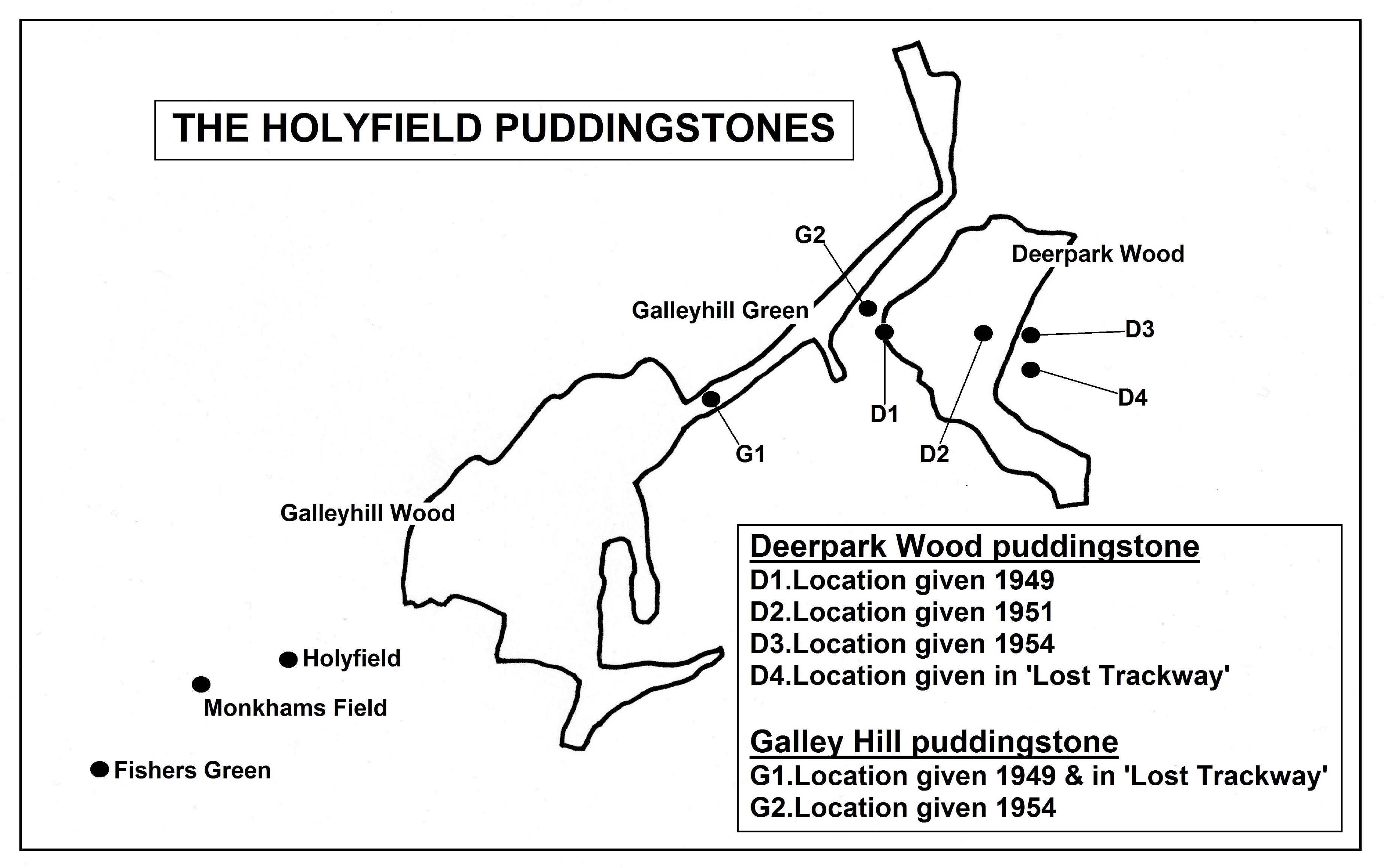
Claverhambury (Waltham Abbey) "In Deerpark Wood" (first mention in print 1950; read 1949): Now we approach the end of the Essex section of the Track, and are close to the stone that started Dr. Rudge's 25-year quest, at Holyfield. Two boulders remain before that, however, the first being somewhere in Deerpark Wood, about a mile west of Parvills Farm. I say 'somewhere', because Rudge never saw it, and gave four very different map references for it. This is a large and ancient piece of woodland, a remnant of the old Waltham Forest, and spreads across the hills just north of the hamlet of Claverhambury.
A forest ranger and a gamekeeper's widow told him of the boulder hidden in dense undergrowth in the wood. It was apparently of Herts Puddingstone, and similar in shape and size to the one at Holyfield, which he already knew about (i.e. roughly conical and about 90cm high.) Despite mentioning it in print at least seven times over the years, Dr. Rudge still never actually located this stone.
Once again - as with the next one - I've used the map that Rudge would have used at the time, the 1946 OS One Inch, to try and gauge the locations that he was trying to convey. The first (stated in 1949) is right on the western edge of Deerpark Wood, at TL405040. In 1951 he placed it 300m further east, at TL408040. By 1954 it had moved another 200m east, to TL410040 - which is actually outside the eastern edge of the wood! Finally, he gave a position of TL410039, which is 100m south of the last point, and even further outside the wood!
Holyfield (Waltham Abbey) "On Galley Hill" (first mention in print 1950; read 1949): The boulder here is again supposed to be similar to that at Holyfield in size, shape and composition (i.e. HPS.) And once again it was said to be hidden in undergrowth, and was never seen by Dr. Rudge. A poacher apparently told him that it was on Galley Hill, "somewhere on the Forest boundary", then confirmed by a ploughman.1 This time we have two different map references, both being in the narrow woodland of Galleyhill Green, a section of which is an isolated part of Epping Forest, and sits just to the west of Deerpark Wood.. The first, given in both 1949 and 'Lost Trackway', is TL400038, a point soon after Galleyhill Green leaves the north-eastern corner of Galleyhill Wood. The second, given only in 1954, places the stone nearly 600m away, halfway along the Green, and outside its eastern side. In fact, it's remarkably close to the first position given above for the Deerpark stone.
Galleyhill Green is now a wooded bridleway, stretching from Aimes Green to Bumble's Green. But it was once "an old Green Lane with wide verges grazed by local cattle who no doubt followed a daily pattern back and forth to be milked and by drover’s cattle going towards London or Waltham Abbey markets".2
1. E.A. Rudge (ed. John Cooper): 'The Lost Trackway' (1994), p.1. 2. Ken Hoy: 'How well do you know the Forest, No.7' in 'The Friends of Epping Forest Newsletter' (July 2000), p.5.
Holyfield (Waltham Abbey) "At roadside, Holyfield" (first mention in print 1950; read 1949):
Here stands the puddingstone that began it all for Dr. Rudge. The hamlet of
Holyfield sits beside the B194, about halfway between Waltham Abbey and
Lower Nazeing. To the east are the rising slopes of Galley Hill, to the west
the lakes and tangled
When Rudge first saw the stone in the spring of 1949, he described it as "a conical-shaped stone standing vertically about thirty inches above ground".1 In 1952 he called it "pear-shaped and obviously weathered and water-worn, about thirty inches high and eighty inches round the base".2 Lilian Rudge in 1962 said it was "about three feet high".3 Both A.E. Salter and Percy Thompson saw it decades earlier, and recorded it as "3'6" x 2'6" x 1'6", containing Tertiary flint pebbles and broken flint".4 My own measurement of it in 2016 shows it to be roughly triangular, 90cm x 75cm x 40cm (36" x 30" x 16".) It now lies flat on the grass rather than upright, but a comparison with Rudge's own photograph of it shows that it was then only lightly embedded, if at all.
1. E.A. & E.L. Rudge: 'Evidence for a Neolithic Trackway in Essex' in 'Essex Naturalist' Vol.28, part 4 (March 1950), p.173 (read 29/10/1949.) 2. E.A. and E.L. Rudge: 'A Stone Age Trade Route in East Anglia' in 'Discovery' magazine Vol.13, No.7 (July 1952), p.207. 3. Lilian Rudge: 'Mystery of the Stones' in 'Essex Countryside' Vol.10, No.68 (Sept. 1962), p.468. 4. A.E. Salter: 'Sarsen, Basalt and Other Boulders in Essex' in 'Essex Naturalist' Vol.17, parts 10-12 (August 1914), p.188.
'Confirmatory evidence' (NOT ON FINAL VERSION OF TRACK) "Saxon road from Holyfield to Thornwood" (only mention 1955): In the first two years of his search for the Track, Dr. Rudge concluded that "As for the track itself, we have found no evidence of its survival, even as fragments, yet many footpaths and by-roads follow very closely in its direction".1 But by 1955 he was saying "in surveying the entire system in detail, it is possible to state that much of the track exists in the real sense. For instance, the Essex section begins in the west at Holyfield, and for the first five miles roughly coincides with the disused road of Saxon origin passing through Gorhambury to Epping Church and on to Thornwood".2 Although Rudge liked to think that such survivals added to the weight of evidence in favour of his Track, the phrase 'roughly coincides' actually suggests that he was seeking too much latitude in this direction.
Gorhambury is undoubtedly an error for Claverhambury. While the latter is close to Holyfield, and in a direct line with Thornwood, Gorhambury is 18 miles away, west of St. Albans. There is in fact no historical or archaeological evidence for this "road of Saxon origin", although the notion may have existed in antiquarian circles of the 19th century. Rudge must have been linking Puck Lane from Holyfield to Aimes Green, then Claverhambury Road to join up with another old drove lane to Parvills Farm, then the road east to Epping church, and finally Upland Road past Pinchtimber and Hayleys to Thornwood. Although it's possible that the drove lanes have a Saxon origin they are more likely to be medieval, as is the road from Parvills to Pinchtimber, linking as it does four of the old manorial homesteads. However, according to the Chapman and André map, there was no road at all between Pinchtimber and Hayleys in 1777. It appears for the first time on the 1839 tithe map, as a narrow track following field boundaries.
There was a theory that an 'ancient British road' (i.e. pre-Roman or Iron Age) ran past Galley Hill and along Epping Long Green to Rye Hill - but again, this is more likely to have been medieval, and it runs up to a mile north of Rudge's route, and roughly parallel to it.3
1. E.A. & E.L. Rudge: 'The Conglomerate Track' in 'Essex Naturalist' Vol.29, part 1 (March 1952), p.19-20 (read 24/11/51.) 2. E.A. Rudge: 'Further Observations on the Conglomerate Track' in 'Essex Naturalist' Vol.29, part 4 (1955), p.258. 3. Benjamin Winstone: 'Extracts from the Minutes of the Epping & Ongar Highway Trust' (Harrison & Sons, 1891), p.13.
Holyfield (Waltham Abbey) "In Monkhams Field, Holyfield" (first mention in print 1950; read 1949): On one of their visits to the puddingstone at Holyfield, the Rudges were told of another "buried in the boulder clay on the slope of a hillock" nearby.1 The location was later pinned down to TL384029, a corner of Monkhams Field close to the B194 Holyfield Road, about 270m WSW of the previous stone. In two articles in 1957 and 1962, Lilian Rudge told the same story that, while she and her husband were picnicking beside the Holyfield stone, they remarked on it to a passing tractor driver. He responded that there was another just like it, just below the surface in the corner of the next field, that the tractor's cutters always caught on when he was clearing thistles. This field was a grassy pasture, as it is now, and it's clear that Rudge never saw the stone himself. In 'Lost Trackway', he said that it was "embedded by a farmer" - which makes no sense to me at all.
1. E.A. & E.L. Rudge: 'Evidence for a Neolithic Trackway in Essex' in 'Essex Naturalist' Vol.28, part 4 (March 1950), p.173 (read 29/10/1949.)
Holyfield (Waltham Abbey) "Fishergreen stone, now buried" (first mention in print 1952; read 1951): As Holyfield Road passes Monkhams Field and leaves Holyfield hamlet behind, it turns southward to skirt Monkhams Hill, and at the junction with Fishers Green Lane becomes Crooked Mile for the rest of its route to Waltham Abbey. In late 1949 Rudge was told of a puddingstone behind a cottage at the junction that faced along Fishers Green Lane, but that cottage was about to be demolished and replaced by a new house. He managed to see the stone, which was almost beneath the surface in the garden, only "a week before it was buried in the foundations of the new building".1
His map reference of
TL381026 lands on Holyfield Farm, about 400m southwest of Monkhams Field,
and the OS Six Inch map of 1947 shows that there was indeed a small building
with a pump behind it at TL38100261. It was on the north side of the main
1. E.A. Rudge (ed. John Cooper): 'The Lost Trackway' (1994), p.1. 2. Information from David Chapman of Holyfield Farm, 22/1/2017.
***********
Given that he couldn't physically locate either of the Deerpark or Galley Hill stones, Rudge's claim that they and the three subsequent Holyfield boulders were "in an almost straight line" is somewhat disingenuous. But the broad north-east to south-west direction of their distribution is what spurred him to investigate further, including westwards into Hertfordshire. He believed that his Track entered that county at Cheshunt, directly west of Holyfield. Specifically, he said "there is little doubt that the River Lea was forded at or near the site of the old 'Water Turnpike', one of the most ancient locks in the country, shown in 18th century maps." It is indeed shown on the 1777 Chapman and André map, just south of Fishers Green. Nowadays Fishers Green Lane ends at a modern series of causeways and footbridges across the river, but it has long been thought that the Lea had once been fordable here. On the Cheshunt side, two suspected Roman roads (Margary 212 and 213) converge on the spot.
|
|