|
Hidden East Anglia: |
The Puddingstone Track: Deconstructed |
|
|
Puddingstone Track Deconstructed: |
Along the Track: county by county
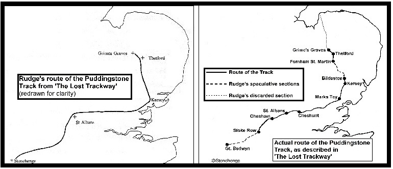
Preface As Dr. Rudge envisaged it, the 'Puddingstone Track' stretched from Norfolk, down through Suffolk, Essex, Hertfordshire, Buckinghamshire, Oxfordshire, Berkshire, and into Wiltshire. In the following sections I have attempted to follow it in that same order, an order which he also laid out in the 'Detailed Itinerary' in the manuscript of his posthumously-published book, 'The Lost Trackway'.
137 stones - or groups of stones - lay along that route. I have examined each site, listing them according to the hamlet, village, town or current civil parish in which they stand, or once stood. Of those 137 I have managed to visit 74. Some stones were buried or destroyed before Rudge even knew of their existence. Some I had determined beforehand had been lost in the years since. There were some sites to which I simply couldn't gain access for one reason or another. And some are completely untraceable due to Rudge giving inaccurate locations, or being deep within woods without a clear idea of where they could be found.
The furthest I ventured south-westwards was to Stoke Row in Oxfordshire. After that point, the route that the Puddingstone Track took became, by his own admission, purely speculative on Rudge's part. Of the final ten stones reported to him in Berkshire and Wiltshire, he definitely never saw eight, and I suspect the same of the other two.
As the project I set for myself was to examine the totality of Dr. Rudge's theory, I couldn't properly research its route without scrutinising the sections and individual stones that he decided to discard along the way. Plus, of course, relatively few people will have read his book, and will only know of the Track through his printed works of the 1950s and 60s.
47 sites were discarded from the earlier iterations of his theory, and of these I have visited 27. On a number of occasions these rejected stones formed series that diverged from the final Track alignment either slightly or significantly. Where these occurred, I have usually found it necessary to explore that divergence in full before returning to the final alignment.
In addition, I have examined much of the 'confirmatory evidence' that Rudge used to support or 'add weight' to his argument. In this I've concentrated on the 'green roads' that he thought were survivals of the Track, and the 'moated mounds' that he was convinced only existed to raise a boulder above the surface for sighting purposes - even though he never found evidence of a single one in situ. From the Suffolk section onwards, with each discarded stone or feature I have flagged it clearly as 'NOT ON FINAL VERSION OF TRACK'.
In 1954 Rudge said that "in every instance the boulder of the track has an undoubted antiquity." On what basis he made that statement is unclear, so where possible I have tried to find some history of the site through books, journals, old photographs, maps, tithe awards etc. Unfortunately, except when noted in local geological reports, most boulders have gone unrecorded. These aren't megaliths that can be studied within the context of a prehistoric landscape. The majority are fairly small rocks that stand at the corners of buildings or in hedgerows, unnoticed by most.
For each stone listed I've begun each entry with the few words that Rudge used to first describe its location. I've also given the first - or only - date that it was mentioned in print. Where I've been able to establish an exact position for the stone, I've given a ten-figure Ordnance Survey National Grid Reference, which pinpoints it to within one metre. (An eight-figure reference narrows it down to a 10 x 10 metre square, while six figures covers an area of 100m x 100m.) Dr. Rudge, an early user of the National Grid system which came into public use after the Second World War, only gave six-figure coordinates. Where practical, I have used the same 1940s and 50s One Inch and 2½ Inch to the mile maps that he would have had, in order to try and determine the locations he was intending.
As stated in the Introduction, throughout I have used the word 'Track' with an initial capital letter in order to distinguish Rudge's proposed prehistoric route from any other trackways that might be discussed.
Where I thought it suitable or necessary, I've also abbreviated Hertfordshire Puddingstone to HPS.
|
|
